Home > North America > Cuba > Cuba Heritage Sites > Old Havana and its Fortification System
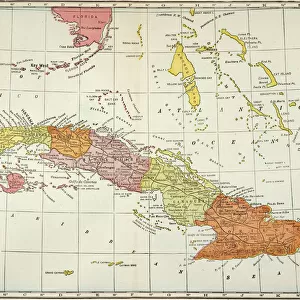
Geography Atlas: representation of the Caribbean Sea region, the Caribbean (Cuba, Jamaica, Hispaniola) and the Lesser Antilles. Map from an Atlas of 1637. Biblioteca Jose Marti, Havana, Cuba
 and the Lesser Antilles. Map from an Atlas of 1637. Biblioteca Jose Marti, Havana, Cuba")
![]()
Wall Art and Photo Gifts from Fine Art Finder
Geography Atlas: representation of the Caribbean Sea region, the Caribbean (Cuba, Jamaica, Hispaniola) and the Lesser Antilles. Map from an Atlas of 1637. Biblioteca Jose Marti, Havana, Cuba
VEN5030071 Geography Atlas: representation of the Caribbean Sea region, the Caribbean (Cuba, Jamaica, Hispaniola) and the Lesser Antilles. Map from an Atlas of 1637. Biblioteca Jose Marti, Havana, Cuba.; (add.info.: Geography Atlas: representation of the Caribbean Sea region, the Caribbean (Cuba, Jamaica, Hispaniola) and the Lesser Antilles. Map from an Atlas of 1637. Biblioteca Jose Marti, Havana, Cuba.); © Marage Photos
Media ID 38425740
© © Marage Photos / Bridgeman Images
17eme Siecle Amerique Centrale Amerique Du Nord Caribbean Carte Geographique Central America Cuba Cuba Cubain Cubaine Cubains Cubaines Cuban Etats Unis Geographie Jamaica Jamaican Stockravenna 17th Centuries Etats Unis Etats Unis Usa United States Geographical Map
FEATURES IN THESE COLLECTIONS
> Fine Art Finder
> Artists
> Pasquier (workshop of) Grenier
> Maps and Charts
> Early Maps
> Maps and Charts
> Related Images
> North America
> Cuba
> Cuba Heritage Sites
> Old Havana and its Fortification System
> North America
> Cuba
> Havana
> North America
> Cuba
> Maps
> North America
> Cuba
> Related Images
> North America
> Jamaica
> Maps
> North America
> Jamaica
> Related Images
> North America
> United States of America
> Maps
EDITORS COMMENTS
This stunning print of a Geography Atlas from 1637 offers a captivating glimpse into the Caribbean Sea region, showcasing the islands of Cuba, Jamaica, Hispaniola, and the Lesser Antilles. The intricate details on this map provide a historical perspective on how these territories were represented in the 17th century.
The map is housed in the Biblioteca Jose Marti in Havana, Cuba, adding to its cultural significance. It serves as a valuable resource for understanding the geographical layout of this area during that time period.
As you study this piece closely, you can appreciate the artistry and precision that went into creating such a detailed representation of these islands. The engraving captures not only their physical features but also hints at the political boundaries and settlements that existed centuries ago.
Whether you have a personal connection to these regions or simply admire historical cartography, this Geography Atlas print is sure to spark your curiosity and appreciation for our world's diverse landscapes. It stands as a testament to human exploration and discovery, inviting viewers to delve deeper into the rich history of the Caribbean and its surrounding seas.
MADE IN THE USA
Safe Shipping with 30 Day Money Back Guarantee
FREE PERSONALISATION*
We are proud to offer a range of customisation features including Personalised Captions, Color Filters and Picture Zoom Tools
SECURE PAYMENTS
We happily accept a wide range of payment options so you can pay for the things you need in the way that is most convenient for you
* Options may vary by product and licensing agreement. Zoomed Pictures can be adjusted in the Cart.