Home > Europe > United Kingdom > England > London > Towns > Willesden
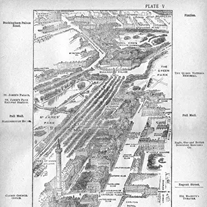
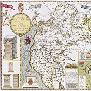
Map of Willesden, London (litho)
")
![]()
Wall Art and Photo Gifts from Fine Art Finder
Map of Willesden, London (litho)
1762020 Map of Willesden, London (litho) by English School; London Metropolitan Archives, City of London; (add.info.: Willesden is an area in North West London which forms part of the London Borough of Brent. It is situated 5 miles (8 km) northwest of Charing Cross. It was historically a parish in the county of Middlesex, that was incorporated as the Municipal Borough of Willesden in 1933 and has formed part of Greater London since 1965.); eLondon Metropolitan Archives; English, out of copyright
Media ID 23103194
© London Metropolitan Archives / Bridgeman Images
Borough Brent Cartographer Middlesex Willesden
FEATURES IN THESE COLLECTIONS
> Europe
> United Kingdom
> England
> Greater London
> Related Images
> Europe
> United Kingdom
> England
> Greater London
> Willesden
> Europe
> United Kingdom
> England
> London
> Boroughs
> Brent
> Europe
> United Kingdom
> England
> London
> Boroughs
> City of London
> Europe
> United Kingdom
> England
> London
> Boroughs
> Related Images
> Europe
> United Kingdom
> England
> London
> Towns
> Brent
> Europe
> United Kingdom
> England
> London
> Towns
> Willesden
> Europe
> United Kingdom
> England
> Maps
> Fine Art Finder
> Artists
> Painter Policoro
> Fine Art Finder
> Artists
> School English
> Fine Art Finder
> Maps (celestial & Terrestrial)
EDITORS COMMENTS
This lithograph print showcases a detailed "Map of Willesden, London" from the 18th century. The map, created by an English School cartographer, offers a glimpse into the historical significance and geographical layout of this North West London area. Willesden, now part of the London Borough of Brent, is located approximately 5 miles northwest of Charing Cross. Once a parish in Middlesex County, it gained municipal status as the Borough of Willesden in 1933 and has been an integral part of Greater London since 1965. The intricately engraved map provides valuable insights into the past with its depiction of roads, landmarks, and boundaries. It serves as a testament to both the artistry and precision involved in cartography during that era. As we explore this vintage piece through time's lens, we are transported back to an era when horse-drawn carriages traversed these streets instead of modern vehicles. The map invites us to imagine bustling markets filled with merchants selling their wares or locals strolling along tree-lined avenues. Preserved within this print is not only a visual representation but also a connection to our shared history. It reminds us that beneath our feet lies layers upon layers of stories waiting to be discovered. Thanks to Bridgeman Images' Fine Art Finder collection and eLondon Metropolitan Archives' dedication to preserving cultural heritage, we can appreciate this remarkable piece for generations to come.
MADE IN THE USA
Safe Shipping with 30 Day Money Back Guarantee
FREE PERSONALISATION*
We are proud to offer a range of customisation features including Personalised Captions, Color Filters and Picture Zoom Tools
SECURE PAYMENTS
We happily accept a wide range of payment options so you can pay for the things you need in the way that is most convenient for you
* Options may vary by product and licensing agreement. Zoomed Pictures can be adjusted in the Cart.