Home > Europe > United Kingdom > England > London > Museums > National Maritime Museum
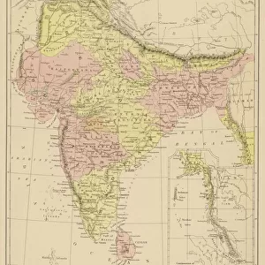
A chart of the Island of Bourbon in the Indian Ocean, 1780 (paper)
")
![]()
Wall Art and Photo Gifts from Fine Art Finder
A chart of the Island of Bourbon in the Indian Ocean, 1780 (paper)
7339415 A chart of the Island of Bourbon in the Indian Ocean, 1780 (paper) by Gilbert, William (18th century); 61x93 cm; National Maritime Museum, London, UK; (add.info.: Creator: William Gilbert; Collier; Samuel Dunn
The island of Reunion. Scale: 1:225 000, in English and Dutch miles and English and French leagues. Rocks and anchorages are indicated on the chart.
This island was discovered near the beginning of the 16th century and named Mascarenhas Isle until the year 1649, when it took the name Bourbon. The torrents formed by rain are considerable and descend with great rapidity. (Probably from Dunn's New Directory for the East Indies).); © National Maritime Museum, Greenwich, London
Media ID 38519856
© © National Maritime Museum, Greenwich, London / Bridgeman Images
Islands Isles South East Asia Asiae
FEATURES IN THESE COLLECTIONS
> Animals
> Insects
> Hemiptera
> Black Scale
> Arts
> Artists
> O
> Oceanic Oceanic
> Arts
> Artists
> W
> William White
> Asia
> India
> Related Images
> Europe
> France
> Heritage Sites
> Pitons, cirques and remparts of Reunion
> Europe
> United Kingdom
> England
> London
> Boroughs
> Greenwich
> Europe
> United Kingdom
> England
> London
> Museums
> Greenwich Heritage Centre
> Europe
> United Kingdom
> England
> London
> Museums
> National Maritime Museum
> Fine Art Finder
> Artists
> Matthew Flinders
> Fine Art Finder
> Artists
> William Gilbert
EDITORS COMMENTS
This stunning print of a chart of the Island of Bourbon in the Indian Ocean, dating back to 1780, offers a fascinating glimpse into the history and geography of this beautiful island. Created by William Gilbert and Samuel Dunn, this detailed map showcases the island, known today as Reunion, with intricate precision.
The chart provides valuable information about the island's topography, including rocks and anchorages that would have been crucial for sailors navigating these waters. The scale is noted in English and Dutch miles as well as English and French leagues, reflecting the diverse influences present in this region during that time period.
Originally named Mascarenhas Isle when it was discovered in the early 16th century, the island was later renamed Bourbon in 1649. The accompanying text on the print highlights how rain torrents shape the landscape of this tropical paradise.
As we admire this historical artifact from the National Maritime Museum in London, we are transported back to a time when exploration and cartography were at their peak. This print serves as a reminder of our enduring fascination with maps and our quest to understand and document our world.
MADE IN THE USA
Safe Shipping with 30 Day Money Back Guarantee
FREE PERSONALISATION*
We are proud to offer a range of customisation features including Personalised Captions, Color Filters and Picture Zoom Tools
SECURE PAYMENTS
We happily accept a wide range of payment options so you can pay for the things you need in the way that is most convenient for you
* Options may vary by product and licensing agreement. Zoomed Pictures can be adjusted in the Cart.