Home > North America > Cuba > Cuba Heritage Sites > Old Havana and its Fortification System
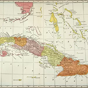
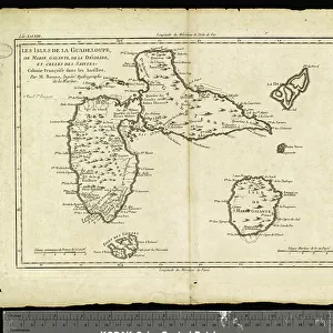
Geography: map of the island of Guadeloupe, Marie Galante, Desirade in the West Indies. Map from an Atlas by Rigobert Bonne (1756-1823) from 1780. Biblioteca Jose Marti, Havana, Cuba
 from 1780. Biblioteca Jose Marti, Havana, Cuba")
![]()
Wall Art and Photo Gifts from Fine Art Finder
Geography: map of the island of Guadeloupe, Marie Galante, Desirade in the West Indies. Map from an Atlas by Rigobert Bonne (1756-1823) from 1780. Biblioteca Jose Marti, Havana, Cuba
VEN5031309 Geography: map of the island of Guadeloupe, Marie Galante, Desirade in the West Indies. Map from an Atlas by Rigobert Bonne (1756-1823) from 1780. Biblioteca Jose Marti, Havana, Cuba; (add.info.: Geography: map of the island of Guadeloupe, Marie Galante, Desirade in the West Indies. Map from an Atlas by Rigobert Bonne (1756-1823) from 1780. Biblioteca Jose Marti, Havana, Cuba); © Marage Photos
Media ID 38274524
© © Marage Photos / Bridgeman Images
Amerique Centrale Amerique Du Nord British West Indies Caraïbes Caribbean Caribbean Island Carte Geographique Central America Etats Unis Geographie Guadeloupe Guadeloupean Stockravenna West Indies 18eme Siecle Geographical Map
FEATURES IN THESE COLLECTIONS
> Fine Art Finder
> Artists
> Marcantonio Bassetti
> Maps and Charts
> Early Maps
> Maps and Charts
> Related Images
> North America
> Cuba
> Cuba Heritage Sites
> Old Havana and its Fortification System
> North America
> Cuba
> Havana
> North America
> Cuba
> Maps
> North America
> Cuba
> Related Images
> North America
> Guadeloupe
> Maps
> North America
> Guadeloupe
> Related Images
> North America
> United States of America
> Maps
EDITORS COMMENTS
This stunning print captures a detailed map of the island of Guadeloupe, Marie Galante, and Desirade in the West Indies. Created by cartographer Rigobert Bonne in 1780, this historical atlas piece is housed in the Biblioteca Jose Marti in Havana, Cuba.
The intricate engraving showcases the topography and geographical features of these Caribbean islands with precision and artistry. From lush forests to winding coastlines, every detail is meticulously depicted on this map from the 18th century.
As you study this map, you can't help but be transported back in time to an era when exploration and discovery were at their peak. The names of towns and landmarks are written in elegant script, adding to the charm and authenticity of this vintage piece.
Guadeloupe's rich history as a French overseas territory comes alive through this map, offering a glimpse into its past as a hub for trade and colonial influence. The British West Indies also make an appearance on this map, highlighting the interconnectedness of these Caribbean islands during that period.
Whether you're a history buff or simply appreciate fine craftsmanship, this Geography: Map of Guadeloupe print is sure to captivate your imagination and inspire wanderlust for these tropical paradises.
MADE IN THE USA
Safe Shipping with 30 Day Money Back Guarantee
FREE PERSONALISATION*
We are proud to offer a range of customisation features including Personalised Captions, Color Filters and Picture Zoom Tools
SECURE PAYMENTS
We happily accept a wide range of payment options so you can pay for the things you need in the way that is most convenient for you
* Options may vary by product and licensing agreement. Zoomed Pictures can be adjusted in the Cart.