Home > Arts > Artists > J > Thomas Jefferys
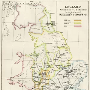
Geography Atlas: representation of Cape Francais (Cap de la Republique) in Santo Domingo in the West Indies. Map from an atlas by Thomas Jefferys, geographer of the Prince of Wales, 1760. Biblioteca Jose Marti, Havana, Cuba
 in Santo Domingo in the West Indies. Map from an atlas by Thomas Jefferys, geographer of the Prince of Wales, 1760. Biblioteca Jose Marti, Havana, Cuba")
![]()
Wall Art and Photo Gifts from Fine Art Finder
Geography Atlas: representation of Cape Francais (Cap de la Republique) in Santo Domingo in the West Indies. Map from an atlas by Thomas Jefferys, geographer of the Prince of Wales, 1760. Biblioteca Jose Marti, Havana, Cuba
VEN5031342 Geography Atlas: representation of Cape Francais (Cap de la Republique) in Santo Domingo in the West Indies. Map from an atlas by Thomas Jefferys, geographer of the Prince of Wales, 1760. Biblioteca Jose Marti, Havana, Cuba.; (add.info.: Geography Atlas: representation of Cape Francais (Cap de la Republique) in Santo Domingo in the West Indies. Map from an atlas by Thomas Jefferys, geographer of the Prince of Wales, 1760. Biblioteca Jose Marti, Havana, Cuba.); © Marage Photos
Media ID 38274542
© © Marage Photos / Bridgeman Images
Amerique Centrale Amerique Du Nord Caraïbes Caribbean Caribbean Island Carte Geographique Central America Dominium Etats Unis Geographie Haiti Saint Domingue Stockravenna 18eme Siecle Geographical Map
FEATURES IN THESE COLLECTIONS
> Arts
> Artists
> J
> Thomas Jefferys
> Arts
> Artists
> N
> Thomas North
> Europe
> United Kingdom
> Wales
> Maps
> Europe
> United Kingdom
> Wales
> Posters
> Europe
> United Kingdom
> Wales
> Related Images
> Fine Art Finder
> Artists
> Marcantonio Bassetti
> Maps and Charts
> Early Maps
> Maps and Charts
> Related Images
> Maps and Charts
> Wales
> North America
> Cuba
> Cuba Heritage Sites
> Old Havana and its Fortification System
EDITORS COMMENTS
This stunning print from an 18th-century Geography Atlas showcases the detailed representation of Cape Francais (Cap de la Republique) in Santo Domingo, located in the West Indies. Created by Thomas Jefferys, a renowned geographer of the Prince of Wales in 1760, this map is a true testament to the artistry and precision of cartography during that era.
The intricate engraving captures the beauty and complexity of the island geography, highlighting key landmarks and topographical features with remarkable accuracy. The map provides valuable insights into the historical significance of Cape Francais and its surrounding areas, offering a glimpse into the past through a geographical lens.
Stored at Biblioteca Jose Marti in Havana, Cuba, this rare piece serves as a reminder of our rich maritime history and exploration endeavors. It reflects not only the advancements in mapping technology but also sheds light on colonial influences and territorial boundaries prevalent during that time period.
As we marvel at this exquisite work of art, we are transported back to an era where discovery and adventure were paramount. The Geography Atlas print stands as a timeless treasure, preserving our collective heritage for generations to come.
MADE IN THE USA
Safe Shipping with 30 Day Money Back Guarantee
FREE PERSONALISATION*
We are proud to offer a range of customisation features including Personalised Captions, Color Filters and Picture Zoom Tools
SECURE PAYMENTS
We happily accept a wide range of payment options so you can pay for the things you need in the way that is most convenient for you
* Options may vary by product and licensing agreement. Zoomed Pictures can be adjusted in the Cart.