Home > Europe > United Kingdom > England > London > Politics > Frederick North
Map of the Gulf and River of St Lawrence, c.1778 (print)
")
![]()
Wall Art and Photo Gifts from Fine Art Finder
Map of the Gulf and River of St Lawrence, c.1778 (print)
7340436 Map of the Gulf and River of St Lawrence, c.1778 (print) by DesBarres, Joseph Frederick Wallet (1721-1824); 76x53.5 cm; National Maritime Museum, London, UK; (add.info.: Creator: Joseph Frederick Wallet Des Barres
Three sheets. Scale: circa 1:500 000 (latitude). Cartographic Note: Variation not shown. Border yellow, coast outlined in blue. Page number 5 type-stamped overleaf.); © National Maritime Museum, Greenwich, London
Media ID 38268898
© © National Maritime Museum, Greenwich, London / Bridgeman Images
FEATURES IN THESE COLLECTIONS
> Animals
> Insects
> Hemiptera
> Yellow Scale
> Europe
> United Kingdom
> England
> London
> Boroughs
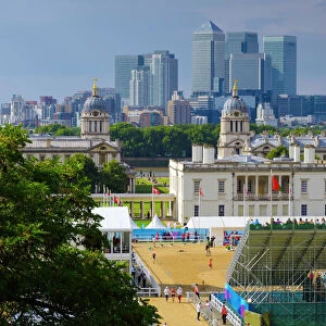
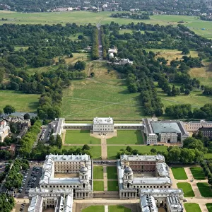
> Greenwich
> Europe
> United Kingdom
> England
> London
> Museums
> Greenwich Heritage Centre
> Europe
> United Kingdom
> England
> London
> Museums
> National Maritime Museum
> Europe
> United Kingdom
> England
> London
> Politics
> Frederick North
> Europe
> United Kingdom
> England
> London
> Towns
> Greenwich
> Europe
> United Kingdom
> Heritage Sites
> Maritime Greenwich
> Europe
> United Kingdom
> Maps
> Fine Art Finder
> Artists
> Joseph Frederick Wallet DesBarres
> Maps and Charts
> Early Maps
EDITORS COMMENTS
This stunning print of the Map of the Gulf and River of St Lawrence, dating back to around 1778, offers a fascinating glimpse into the cartographic expertise of Joseph Frederick Wallet DesBarres. The intricate details and vibrant colors used in this map showcase the skill and precision that went into its creation during the 18th century.
Measuring at 76x53.5 cm, this three-sheet map provides a scale of approximately 1:500,000 in latitude, with a border highlighted in yellow and coastlines outlined in blue. The meticulous attention to detail is evident throughout, from the carefully labeled geographical features to the type-stamped page number '5' overleaf.
As you study this historical artifact, you can't help but be transported back in time to an era when exploration and discovery were at the forefront of human endeavor. The map not only serves as a navigational tool but also as a work of art that captures the essence of early cartography.
Displayed at the National Maritime Museum in London, UK, this print is a testament to DesBarres' legacy as one of history's most skilled mapmakers. It stands as a reminder of our enduring fascination with geography and our relentless quest for knowledge about the world around us.
MADE IN THE USA
Safe Shipping with 30 Day Money Back Guarantee
FREE PERSONALISATION*
We are proud to offer a range of customisation features including Personalised Captions, Color Filters and Picture Zoom Tools
SECURE PAYMENTS
We happily accept a wide range of payment options so you can pay for the things you need in the way that is most convenient for you
* Options may vary by product and licensing agreement. Zoomed Pictures can be adjusted in the Cart.