Home > Animals > Mammals > Muridae > Western Mouse
A new and general map of the middle dominion belonging to the United States

![]()
Wall Art and Photo Gifts from Fine Art Finder
A new and general map of the middle dominion belonging to the United States
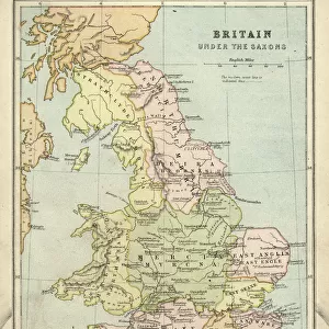
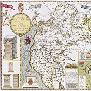
696116 A new and general map of the middle dominion belonging to the United States, 14th May 1794 (colour litho) by Whittle, James (1757-1818) and Laurie, Robert (1755-1836); 53.5x74 cm; Gilder Lehrman Collection, New York, USA; (add.info.: The map shows part of the United States, from western New England to Michigan, and from Vermont to southern Virginia.); eGilder Lehrman Institute of American History; American, out of copyright
Media ID 23228164
© Gilder Lehrman Institute of American History / Bridgeman Images
Lake Erie Mapping Michigan New England Republic Vermont Lake Ontario
FEATURES IN THESE COLLECTIONS
> Animals
> Mammals
> Muridae
> Western Mouse
> Arts
> Artists
> R
> James Roberts
> Europe
> United Kingdom
> England
> Lakes
> Europe
> United Kingdom
> England
> Maps
> Europe
> United Kingdom
> England
> York
> Fine Art Finder
> Artists
> James and Laurie Robert (1755-1836)
> Fine Art Finder
> Maps (celestial & Terrestrial)
> Maps and Charts
> Related Images
> North America
> United States of America
> Lakes
> Lake Erie
> North America
> United States of America
> Lakes
> Lake Michigan
> North America
> United States of America
> Lakes
> Lake Ontario
EDITORS COMMENTS
This print showcases "A new and general map of the middle dominion belonging to the United States" created on May 14th, 1794. Crafted by renowned cartographers James Whittle and Robert Laurie, this colorful lithograph measures 53.5x74 cm and is part of the esteemed Gilder Lehrman Collection in New York. The map offers a comprehensive view of a significant portion of the United States during the late 18th century. Stretching from western New England to Michigan, and from Vermont to southern Virginia, it provides valuable insights into the American landscape at that time. With intricate details highlighting various regions such as Lake Erie, Lake Ontario, South Virginia, Michigan, Vermont, and more; this piece serves as an invaluable resource for historians and geographers alike. Its meticulous representation allows viewers to explore how these areas were perceived during America's early years as a republic. As we delve into this remarkable artifact from our past, we are transported back to a time when mapping was both an art form and a scientific endeavor. The delicate strokes capture not only geographical features but also provide glimpses into the cultural fabric of those times. Through this print courtesy of Bridgeman Images' Fine Art Finder collection, we can appreciate the beauty and historical significance embedded within this extraordinary map—a true testament to human curiosity about our world's ever-evolving landscapes.
MADE IN THE USA
Safe Shipping with 30 Day Money Back Guarantee
FREE PERSONALISATION*
We are proud to offer a range of customisation features including Personalised Captions, Color Filters and Picture Zoom Tools
SECURE PAYMENTS
We happily accept a wide range of payment options so you can pay for the things you need in the way that is most convenient for you
* Options may vary by product and licensing agreement. Zoomed Pictures can be adjusted in the Cart.