Home > Europe > United Kingdom > England > London > Museums > National Maritime Museum
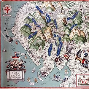
Map of the Isle of Bourbon prepared at the depository of maps and seacharts, 1763 (coloured engraving)
")
![]()
Wall Art and Photo Gifts from Fine Art Finder
Map of the Isle of Bourbon prepared at the depository of maps and seacharts, 1763 (coloured engraving)
7339382 Map of the Isle of Bourbon prepared at the depository of maps and seacharts, 1763 (coloured engraving) by Bellin, Jacques Nicolas (1703-72) ; 67x77 cm; National Maritime Museum, London, UK; (add.info.: Creator: Jacques Nicolas Bellin
Single sheet. Hand col. engr. Physical description Note: Pink linen backing. Scale: [ca. 1:150 000 (bar)]. Cartographic Note: Graduated map. Paris meridian. Rhumb lines. Scale in French leagues. Additional Places: Reunion. Inscribed Carte de l'Isle de Bourbon dressee au depost des cartes et plans de la marine par Ordre de M. le Duc de Choiseul.... Par le Sr Bellin... 1763'.); © National Maritime Museum, Greenwich, London
Media ID 38176936
© © National Maritime Museum, Greenwich, London / Bridgeman Images
Dom Tom Islands Isles Mascarene Islands Reunion Island
FEATURES IN THESE COLLECTIONS
> Europe
> France
> Heritage Sites
> Pitons, cirques and remparts of Reunion
> Europe
> France
> Paris
> Maps
> Europe
> United Kingdom
> England
> London
> Boroughs
> Greenwich
> Europe
> United Kingdom
> England
> London
> Museums
> Greenwich Heritage Centre
> Europe
> United Kingdom
> England
> London
> Museums
> National Maritime Museum
> Europe
> United Kingdom
> England
> London
> Towns
> Greenwich
> Europe
> United Kingdom
> Heritage Sites
> Maritime Greenwich
> Europe
> United Kingdom
> Maps
> Fine Art Finder
> Artists
> Jacques Nicolas Bellin
EDITORS COMMENTS
This stunning colored engraving of the Map of the Isle of Bourbon, prepared in 1763 by Jacques Nicolas Bellin, is a true masterpiece of cartography. The intricate details and vibrant colors bring this historic map to life, showcasing the beauty and complexity of Reunion Island in the Indian Ocean.
The meticulous craftsmanship and attention to detail in this map reflect the skill and expertise of Bellin as a renowned cartographer. The Paris meridian, rhumb lines, and scale in French leagues all contribute to making this map not only visually striking but also incredibly informative for navigation purposes.
As you study this print closely, you can imagine sailors using it to chart their course through the waters surrounding Reunion Island. The pink linen backing adds a touch of elegance to this already impressive piece, making it a valuable addition to any collection of maps or historical artwork.
Overall, this Map of the Isle of Bourbon is a testament to Bellin's talent as a cartographer and serves as a reminder of the rich history and cultural significance of Reunion Island. Displaying this print in your home or office will surely spark conversations about exploration, navigation, and the enduring appeal of beautifully crafted maps.
MADE IN THE USA
Safe Shipping with 30 Day Money Back Guarantee
FREE PERSONALISATION*
We are proud to offer a range of customisation features including Personalised Captions, Color Filters and Picture Zoom Tools
SECURE PAYMENTS
We happily accept a wide range of payment options so you can pay for the things you need in the way that is most convenient for you
* Options may vary by product and licensing agreement. Zoomed Pictures can be adjusted in the Cart.