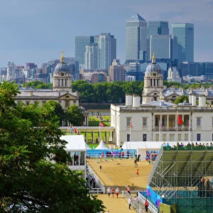
Home > Europe > United Kingdom > England > London > Museums > National Maritime Museum
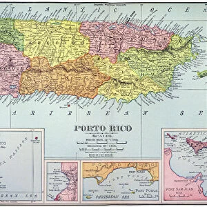
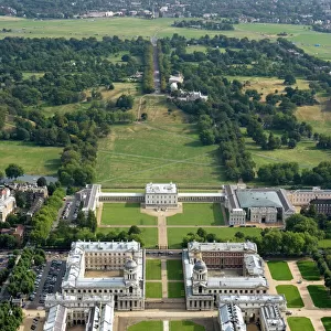
Eastern Caribbean, 1658 (engraving)
")
![]()
Wall Art and Photo Gifts from Fine Art Finder
Eastern Caribbean, 1658 (engraving)
7340063 Eastern Caribbean, 1658 (engraving) by Doncker, Hendrick (c.1626-99); 44.5x54 cm; National Maritime Museum, London, UK; (add.info.: Creator: Hendrik Doncker
This chart shows North at 90 degrees, the borders are graduated for latitude and it has Puerto Rico, Leeward Islands, Windward Islands, Trinidad and Venezuela represented. It's bound in De Zee-Atlas ofte Water-wareld, published by Doncker in 1661.); © National Maritime Museum, Greenwich, London
Media ID 38412532
© © National Maritime Museum, Greenwich, London / Bridgeman Images
Caribbean 17th Centuries Geographer
FEATURES IN THESE COLLECTIONS
> Arts
> Artists
> D
> Hendrick Doncker
> Europe
> United Kingdom
> England
> London
> Boroughs
> Greenwich
> Europe
> United Kingdom
> England
> London
> Museums
> Greenwich Heritage Centre
> Europe
> United Kingdom
> England
> London
> Museums
> National Maritime Museum
> Europe
> United Kingdom
> England
> London
> Towns
> Greenwich
> Europe
> United Kingdom
> Heritage Sites
> Maritime Greenwich
> Europe
> United Kingdom
> Maps
> Fine Art Finder
> Artists
> Frederick de Wit
> Fine Art Finder
> Artists
> Hendrick Doncker
> Maps and Charts
> Early Maps
> Maps and Charts
> Related Images
> North America
> Puerto Rico
> Maps
EDITORS COMMENTS
This stunning engraving from 1658 captures the beauty and intricacy of the Eastern Caribbean region. Created by Hendrick Doncker, a skilled cartographer of the 17th century, this chart showcases his attention to detail and precision in mapping out Puerto Rico, the Leeward Islands, Windward Islands, Trinidad, and Venezuela.
The map is oriented with North at 90 degrees and features graduated borders for latitude, providing a clear and accurate representation of the area. This piece is bound in 'De Zee-Atlas ofte Water-wareld', a publication by Doncker in 1661 that highlights his expertise in cartography.
The vibrant colors used in this engraving bring life to the geographical features depicted, making it not only informative but visually captivating as well. The intricate lines and symbols on the map showcase Doncker's skill as an engraver and geographer during this period.
As we gaze upon this historical artwork, we are transported back to a time when exploration and discovery were paramount. The Eastern Caribbean comes alive through Doncker's meticulous craftsmanship, offering us a glimpse into the past while also serving as a reminder of the importance of preserving our rich history for future generations to appreciate.
MADE IN THE USA
Safe Shipping with 30 Day Money Back Guarantee
FREE PERSONALISATION*
We are proud to offer a range of customisation features including Personalised Captions, Color Filters and Picture Zoom Tools
SECURE PAYMENTS
We happily accept a wide range of payment options so you can pay for the things you need in the way that is most convenient for you
* Options may vary by product and licensing agreement. Zoomed Pictures can be adjusted in the Cart.