Home > North America > Dominican Republic > Maps
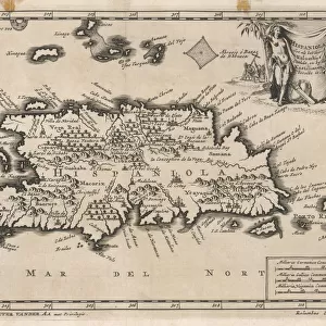
Map of Espanola with the Columbine Forts and settlements. From the book Life of Christopher Columbus by Clements R. Markham published 1892

![]()
Wall Art and Photo Gifts from Fine Art Finder
Map of Espanola with the Columbine Forts and settlements. From the book Life of Christopher Columbus by Clements R. Markham published 1892
2915321 Map of Espanola with the Columbine Forts and settlements. From the book Life of Christopher Columbus by Clements R. Markham published 1892.; Photo © Hilary Morgan
Media ID 38317034
© © Hilary Morgan / Bridgeman Images
Chart Christopher Colon Colonies Columbine Columbus Cristobal Cristoval Dominican Espanola Forts Geographical Mapmaking New World Republic Settlements
FEATURES IN THESE COLLECTIONS
> Fine Art Finder
> Artists
> Frank Reynolds
> Maps and Charts
> Related Images
> Maps and Charts
> World
> North America
> Dominican Republic
> Maps
> North America
> Dominican Republic
> Related Images
EDITORS COMMENTS
This stunning print captures a historical map of Espanola, showcasing the Columbine Forts and settlements from the book "Life of Christopher Columbus" by Clements R. Markham, published in 1892. The intricate details on this map provide a glimpse into the geographical layout of the colony during Columbus' voyages to the New World.
As we study this map, we can imagine the challenges and triumphs faced by early explorers as they navigated through uncharted territories, seeking new opportunities and discoveries. The strategic placement of forts and settlements on Espanola reflects the efforts to establish a presence in this unfamiliar land.
The island of Cristobal (Christopher) Columbus is prominently featured on this map, serving as a reminder of his significant role in shaping world history. The detailed charting of colonies and geography highlights the meticulous work that went into mapmaking during this era.
This print not only serves as a visual representation of historical events but also sparks curiosity about past civilizations and their interactions with newly discovered lands. It invites us to explore further into the rich history of colonialism and exploration that has shaped our modern world.
MADE IN THE USA
Safe Shipping with 30 Day Money Back Guarantee
FREE PERSONALISATION*
We are proud to offer a range of customisation features including Personalised Captions, Color Filters and Picture Zoom Tools
SECURE PAYMENTS
We happily accept a wide range of payment options so you can pay for the things you need in the way that is most convenient for you
* Options may vary by product and licensing agreement. Zoomed Pictures can be adjusted in the Cart.