Home > Europe > United Kingdom > England > London > Museums > National Maritime Museum
Map of Virginia, 1585 (etching)
")
![]()
Wall Art and Photo Gifts from Fine Art Finder
Map of Virginia, 1585 (etching)
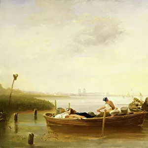
7295569 Map of Virginia, 1585 (etching); 30x41.2 cm; National Maritime Museum, London, UK; (add.info.: This map was drawn by John White, the official artist on the expedition to North America in 1585, which was promoted by Sir Walter Raleigh.); © National Maritime Museum, Greenwich, London
Media ID 38431310
© © National Maritime Museum, Greenwich, London / Bridgeman Images
FEATURES IN THESE COLLECTIONS
> Arts
> Artists
> W
> John White
> Europe
> Republic of Ireland
> Maps
> Europe
> United Kingdom
> England
> London
> Boroughs
> Greenwich
> Europe
> United Kingdom
> England
> London
> Museums
> British Museum
> Europe
> United Kingdom
> England
> London
> Museums
> Greenwich Heritage Centre
> Europe
> United Kingdom
> England
> London
> Museums
> National Maritime Museum
> Europe
> United Kingdom
> England
> London
> Sights
> British Museum
> Europe
> United Kingdom
> England
> London
> Towns
> Greenwich
> Europe
> United Kingdom
> Heritage Sites
> Maritime Greenwich
> Europe
> United Kingdom
> Maps
> Fine Art Finder
> Artists
> British School
EDITORS COMMENTS
This etching of the Map of Virginia from 1585 offers a glimpse into the early exploration and cartography of North America. Drawn by John White, the official artist on Sir Walter Raleigh's expedition, this map is a testament to the curiosity and ambition of European explorers in the 16th century.
The intricate details and precise lines on this map showcase the skill and artistry involved in creating such historical documents. From the coastlines to the rivers and mountains, every element is meticulously depicted, providing valuable insights into how Europeans perceived and navigated through this new land.
As we study this map, we are transported back in time to an era when discovery and adventure were at the forefront of exploration. The names of towns and landmarks marked on the map give us a sense of how early settlers interacted with their surroundings and established communities in what would eventually become known as Virginia.
With its black-and-white aesthetic, this etching exudes a timeless quality that allows us to appreciate both its historical significance and artistic beauty. It serves as a reminder of our enduring fascination with maps as windows into different worlds and eras.
MADE IN THE USA
Safe Shipping with 30 Day Money Back Guarantee
FREE PERSONALISATION*
We are proud to offer a range of customisation features including Personalised Captions, Color Filters and Picture Zoom Tools
SECURE PAYMENTS
We happily accept a wide range of payment options so you can pay for the things you need in the way that is most convenient for you
* Options may vary by product and licensing agreement. Zoomed Pictures can be adjusted in the Cart.