Home > Animals > Insects > Spiders > European Garden
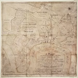
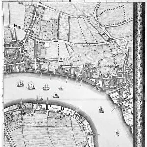
Map of Barnes, Battersea, Putney and Wandsworth, 1746 (coloured engraving)
")
![]()
Wall Art and Photo Gifts from Fine Art Finder
Map of Barnes, Battersea, Putney and Wandsworth, 1746 (coloured engraving)
7340513 Map of Barnes, Battersea, Putney and Wandsworth, 1746 (coloured engraving) by Rocque, John (c.1704-d.1762); 51x67 cm; National Maritime Museum, London, UK; (add.info.: Creator: John Rocque
Sheet from An exact survey of the cities of London and Westminster, the Borough of Southwark, with the country near ten miles round'. John Rocque came to England as a child with his French Huguenot family. He was an estate surveyor and garden designer before he began mapping towns.); © National Maritime Museum, Greenwich, London
Media ID 38410232
© © National Maritime Museum, Greenwich, London / Bridgeman Images
FEATURES IN THESE COLLECTIONS
> Animals
> Insects
> Spiders
> European Garden
> Arts
> Artists
> R
> John Rocque
> Europe
> Republic of Ireland
> Maps
> Europe
> United Kingdom
> England
> London
> Boroughs
> City of Westminster
> Europe
> United Kingdom
> England
> London
> Boroughs
> Greenwich
> Europe
> United Kingdom
> England
> London
> Boroughs
> Related Images
> Europe
> United Kingdom
> England
> London
> Boroughs
> Southwark
> Europe
> United Kingdom
> England
> London
> Boroughs
> Wandsworth
> Europe
> United Kingdom
> England
> London
> Museums
> British Museum
> Fine Art Finder
> Artists
> British School
> Fine Art Finder
> Artists
> John Rocque
EDITORS COMMENTS
This beautifully detailed coloured engraving from 1746 depicts a map of Barnes, Battersea, Putney, and Wandsworth, created by the talented John Rocque. The intricate design showcases the streets, buildings, and landscapes of these historic areas in London during the 18th century.
John Rocque's expertise as an estate surveyor and garden designer shines through in this map, providing a unique perspective on the layout of these towns. His meticulous attention to detail captures the essence of each location with precision and accuracy.
As you study this print closely, you can imagine what life was like in these bustling communities over two centuries ago. The vibrant colours bring the map to life, allowing you to immerse yourself in the rich history of London during this period.
Whether you are a history enthusiast or simply appreciate fine cartography, this print is sure to captivate your imagination and transport you back in time. Explore the streets and landmarks of Barnes, Battersea, Putney, and Wandsworth as they appeared in 1746 through the eyes of John Rocque's masterful work.
MADE IN THE USA
Safe Shipping with 30 Day Money Back Guarantee
FREE PERSONALISATION*
We are proud to offer a range of customisation features including Personalised Captions, Color Filters and Picture Zoom Tools
SECURE PAYMENTS
We happily accept a wide range of payment options so you can pay for the things you need in the way that is most convenient for you
* Options may vary by product and licensing agreement. Zoomed Pictures can be adjusted in the Cart.