Home > Europe > United Kingdom > England > London > Museums > National Maritime Museum
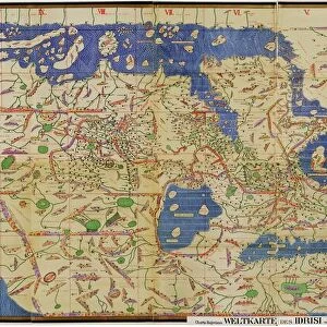
Sapoticlan and Sacatepeque, 1685 (bound sheet)
")
![]()
Wall Art and Photo Gifts from Fine Art Finder
Sapoticlan and Sacatepeque, 1685 (bound sheet)
7339681 Sapoticlan and Sacatepeque, 1685 (bound sheet) by Hack, William (17th Century); 40x50 cm; National Maritime Museum, London, UK; (add.info.: Creator: William Hack
North America, the Pacific Coast and Guatemala. Bound in A Wagoner of the South Sea describing the sea coast from Acapulco to Albemarle isle, an English translation of a Spanish derrotero captured from the Spanish ship Rosario by Captain Bartholomew Sharpe in 1680. Hack made multiple copies of this atlas. This one was presented to James II. It shows Sharpe's track, depicts the silver mine at Potosi, has a decorated title cartouche and scale.); © National Maritime Museum, Greenwich, London
Media ID 38176562
© © National Maritime Museum, Greenwich, London / Bridgeman Images
Central America Coast Line Guatemala Guatimala Republic Of Guatemala
FEATURES IN THESE COLLECTIONS
> Arts
> Artists
> J
> William James
> Europe
> Spain
> Related Images
> Europe
> United Kingdom
> England
> London
> Boroughs
> Greenwich
> Europe
> United Kingdom
> England
> London
> Museums
> Greenwich Heritage Centre
> Europe
> United Kingdom
> England
> London
> Museums
> National Maritime Museum
> Europe
> United Kingdom
> England
> London
> Towns
> Greenwich
> Europe
> United Kingdom
> Heritage Sites
> Maritime Greenwich
> Europe
> United Kingdom
> Maps
> Fine Art Finder
> Artists
> Basil Ringrose
> Fine Art Finder
> Artists
> William Hack
EDITORS COMMENTS
This print of Sapoticlan and Sacatepeque from 1685 offers a glimpse into the intricate cartography of William Hack, a prominent figure in 17th-century mapmaking. The bound sheet is part of an atlas titled 'A Wagoner of the South Sea', which details the sea coast from Acapulco to Albemarle Isle, captured from a Spanish derrotero by Captain Bartholomew Sharpe in 1680.
Hack's meticulous attention to detail is evident in this piece, showcasing North America, the Pacific Coast, and Guatemala with precision and artistry. The map includes Sharpe's track, illustrations of the silver mine at Potosi, and a beautifully decorated title cartouche with a scale for reference.
Presented to James II as a gift, this particular copy of Hack's atlas is now housed at the National Maritime Museum in London. The vibrant colors and expertly drawn coastline bring to life the maritime history and exploration of the era.
As you study this print closely, you can almost feel yourself transported back to the early 17th century, imagining sailors navigating these waters with nothing but their wits and maps like this one. It serves as both a historical artifact and a work of art that continues to captivate viewers centuries later.
MADE IN THE USA
Safe Shipping with 30 Day Money Back Guarantee
FREE PERSONALISATION*
We are proud to offer a range of customisation features including Personalised Captions, Color Filters and Picture Zoom Tools
SECURE PAYMENTS
We happily accept a wide range of payment options so you can pay for the things you need in the way that is most convenient for you
* Options may vary by product and licensing agreement. Zoomed Pictures can be adjusted in the Cart.