Home > Europe > United Kingdom > England > London > Museums > National Maritime Museum
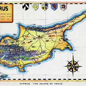
Map of Cyprus, c.1485 (vellum)
")
![]()
Wall Art and Photo Gifts from Fine Art Finder
Map of Cyprus, c.1485 (vellum)
7339636 Map of Cyprus, c.1485 (vellum) by Sonetti, Bartolomeo da li (fl.1485); 27.5x38 cm; National Maritime Museum, London, UK; (add.info.: Creator: Bartolommeo dalli Sonetti
Bound sheets. Scale: [ca. 1:5 000 000]. In an Isolario (island book) of 58ff. The text is in verse, dedicated to Giovanni Mozenico, Doge of Venice 1475-85.); © National Maritime Museum, Greenwich, London
Media ID 38509986
© © National Maritime Museum, Greenwich, London / Bridgeman Images
Cyprus 15th 15 Xv Xvth Fifteenth Century Geographer
FEATURES IN THESE COLLECTIONS
> Asia
> Cyprus
> Related Images
> Europe
> United Kingdom
> England
> London
> Boroughs
> Greenwich
> Europe
> United Kingdom
> England
> London
> Museums
> Greenwich Heritage Centre
> Europe
> United Kingdom
> England
> London
> Museums
> National Maritime Museum
> Europe
> United Kingdom
> England
> London
> Towns
> Greenwich
> Europe
> United Kingdom
> Heritage Sites
> Maritime Greenwich
> Europe
> United Kingdom
> Maps
> Fine Art Finder
> Artists
> Bartolomeo da li Sonetti
> Maps and Charts
> Related Images
EDITORS COMMENTS
This stunning print showcases a Map of Cyprus dating back to around 1485, created by Bartolomeo da li Sonetti. The intricate details and vibrant colors of this vellum map transport us back in time to the 15th century, providing a glimpse into the cartography of that era.
Measuring at 27.5x38 cm, this map is part of an Isolario (island book) consisting of 58 bound sheets. The scale is approximately 1:5,000,000, offering a comprehensive view of the island's geography and topography. The text accompanying the map is written in verse and dedicated to Giovanni Mozenico, Doge of Venice from 1475-85.
The artistry and craftsmanship displayed in this work are truly remarkable, showcasing the skill and expertise of Bartolomeo da li Sonetti as a geographer and cartographer. The colors used in this map add depth and dimension to the various regions depicted on Cyprus.
Displayed at the National Maritime Museum in London, UK, this piece serves as both a historical artifact and a work of art. It provides valuable insight into how maps were created during the late 15th century while also highlighting the beauty found within cartographic works.
Overall, this Map of Cyprus offers viewers a unique opportunity to appreciate both the history and artistic merit behind such creations from centuries past.
MADE IN THE USA
Safe Shipping with 30 Day Money Back Guarantee
FREE PERSONALISATION*
We are proud to offer a range of customisation features including Personalised Captions, Color Filters and Picture Zoom Tools
SECURE PAYMENTS
We happily accept a wide range of payment options so you can pay for the things you need in the way that is most convenient for you
* Options may vary by product and licensing agreement. Zoomed Pictures can be adjusted in the Cart.