Home > Arts > Artists > W > John White
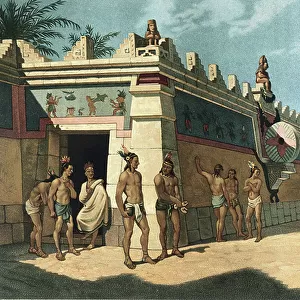
Map of Virginia and Carolina coasts drawn up by John White where Roanoke Colony was located, 16th century. Colouring engraving of the 19th century

![]()
Wall Art and Photo Gifts from Fine Art Finder
Map of Virginia and Carolina coasts drawn up by John White where Roanoke Colony was located, 16th century. Colouring engraving of the 19th century
NWI4849927 Map of Virginia and Carolina coasts drawn up by John White where Roanoke Colony was located, 16th century. Colouring engraving of the 19th century.; (add.info.: Map of Virginia and Carolina coasts drawn up by John White where Roanoke Colony was located, 16th century. Colouring engraving of the 19th century.); Photo © North Wind Pictures
Media ID 38426598
© © North Wind Pictures / Bridgeman Images
Discovered From America Geographical Map
FEATURES IN THESE COLLECTIONS
> Arts
> Artists
> W
> John White
> Fine Art Finder
> Artists
> Artist Unknown
> Maps and Charts
> Related Images
> North America
> United States of America
> Maps
> North America
> United States of America
> North Carolina
> Related Images
> North America
> United States of America
> Virginia
> Related Images
EDITORS COMMENTS
This stunning print showcases a map of the Virginia and Carolina coasts drawn up by John White in the 16th century, where the mysterious Roanoke Colony was located. The intricate details of this historical map are brought to life through the vibrant coloring engraving from the 19th century.
As we gaze upon this piece of cartographic art, we are transported back in time to an era of exploration and discovery. John White's meticulous work captures the essence of a land waiting to be explored, with its uncharted territories and unknown possibilities.
The Roanoke Colony, shrouded in mystery and intrigue, is highlighted on this map as a symbol of early attempts at colonization in North America. The delicate colors used in this engraving add depth and dimension to White's original drawings, allowing us to appreciate his skill as both an explorer and artist.
Through this photo print, we can appreciate not only the historical significance of John White's map but also the beauty that can be found in centuries-old cartography. It serves as a reminder of our enduring fascination with maps as windows into the past and guides for future adventures.
MADE IN THE USA
Safe Shipping with 30 Day Money Back Guarantee
FREE PERSONALISATION*
We are proud to offer a range of customisation features including Personalised Captions, Color Filters and Picture Zoom Tools
SECURE PAYMENTS
We happily accept a wide range of payment options so you can pay for the things you need in the way that is most convenient for you
* Options may vary by product and licensing agreement. Zoomed Pictures can be adjusted in the Cart.