Home > Historic > Ancient civilizations > Ancient Greece > Greek history
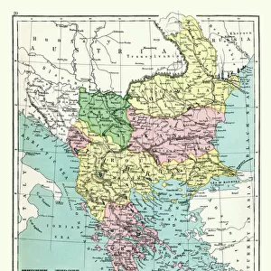
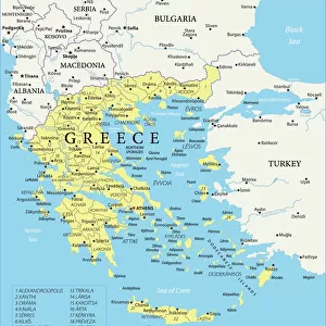
Map of the Greek Empire after the submission of Bulgaria and Italy under the reign of the Franconian (Salian) emperors at the time of the Conquete of the Normans, 1002-1125 (Map of Greece and Italy)
 emperors at the time of the Conquete of the Normans, 1002-1125 (Map of Greece and Italy)")
![]()
Wall Art and Photo Gifts from Fine Art Finder
Map of the Greek Empire after the submission of Bulgaria and Italy under the reign of the Franconian (Salian) emperors at the time of the Conquete of the Normans, 1002-1125 (Map of Greece and Italy)
ELD4924843 Map of the Greek Empire after the submission of Bulgaria and Italy under the reign of the Franconian (Salian) emperors at the time of the Conquete of the Normans, 1002-1125 (Map of Greece and Italy, 1002-1125) Plate from " Atlas Universel" by Houze, 1851 Private collection; (add.info.: Map of the Greek Empire after the submission of Bulgaria and Italy under the reign of the Franconian (Salian) emperors at the time of the Conquete of the Normans, 1002-1125 (Map of Greece and Italy, 1002-1125) Plate from " Atlas Universel" by Houze, 1851 Private collection); Photo © The Holbarn Archive
Media ID 38418828
© © The Holbarn Archive / Bridgeman Images
1 1st I Ist Century 1 Century 11 11th 11th Xi 11th 11th Century 11 11th Xi Xith Century 11 Century 11th Century 12 12th Xii Xiith Century 12 Century 13 13th Xiii Xiiith Thirteenth Century 1st 1st 1st Century 1st Century 1st Century Ad Bulgaria Bulgarian C11th C12th C1st Eleventh Century First Century First Christian Century I Century Ist Century Sec Xi The 13th Century Twelfth Century Xi Century Xii Century Xiith Century Xith Century 12 12th 12th Xii 12th 13th Century 13 13th Xiii Xiiith Century 13 Century C13th Geographical Map Grece Isadora Thirteenth Century Xiii Century Xiiith Century
FEATURES IN THESE COLLECTIONS
> Europe
> Bulgaria
> Related Images
> Europe
> Greece
> Related Images
> Fine Art Finder
> Artists
> Artist Unknown
> Historic
> Ancient civilizations
> Ancient Greece
> Greek history
EDITORS COMMENTS
This stunning print showcases a detailed map of the Greek Empire during a pivotal period in history. The map depicts the empire after the submission of Bulgaria and Italy under the rule of the Franconian (Salian) emperors, at a time when Normans were making their conquests from 1002 to 1125.
The intricate details on this map provide a glimpse into the political landscape of Europe during this era. It highlights the vast territories controlled by the Greek Empire, as well as its influence over neighboring regions such as Bulgaria and Italy. The strategic importance of these territories is evident, especially considering their submission under Franconian rule.
The historical significance captured in this image is truly remarkable. It offers viewers a visual representation of how power dynamics shifted and evolved during this period, with empires rising and falling as conquerors made their mark on the world stage.
Overall, this print serves as both an educational tool and a work of art. Its depiction of ancient borders and alliances invites viewers to delve deeper into the complexities of European history, while also appreciating the beauty and precision with which it was crafted.
MADE IN THE USA
Safe Shipping with 30 Day Money Back Guarantee
FREE PERSONALISATION*
We are proud to offer a range of customisation features including Personalised Captions, Color Filters and Picture Zoom Tools
SECURE PAYMENTS
We happily accept a wide range of payment options so you can pay for the things you need in the way that is most convenient for you
* Options may vary by product and licensing agreement. Zoomed Pictures can be adjusted in the Cart.