Home > Arts > Artists > B > Willem Blaeu
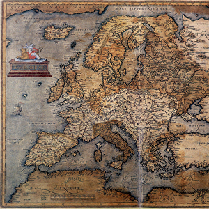
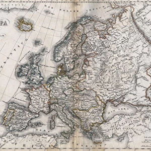
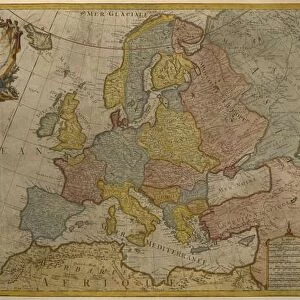
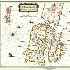
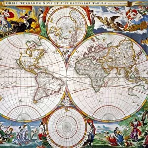
Map of Europe. (engraving, 1638)
")
![]()
Wall Art and Photo Gifts from Fine Art Finder
Map of Europe. (engraving, 1638)
LRI4678144 Map of Europe. (engraving, 1638) by Blaeu, Willem (1571-1638); Private Collection; (add.info.: Map of Europe. Plate from an Atlas by Willem Janszoon Blaeu (Guilielmus Jansonius Blavius) (1571-1638) 1638 Private collection); Luisa Ricciarini; Dutch, out of copyright
Media ID 22836910
© Luisa Ricciarini / Bridgeman Images
Atlantic Ocean Atlas Book Mediterranean Sea Geographical Map
FEATURES IN THESE COLLECTIONS
> Arts
> Artists
> B
> Willem Blaeu
> Arts
> Artists
> O
> Oceanic Oceanic
> Europe
> Related Images
> Fine Art Finder
> Artists
> Anonymous
> Fine Art Finder
> Artists
> Willem Blaeu
> Maps and Charts
> Related Images
> Maps and Charts
> Willem Janszoon Blaeu
EDITORS COMMENTS
This print showcases a remarkable engraving of the "Map of Europe" created by the renowned cartographer Willem Janszoon Blaeu in 1638. The intricate details and exquisite craftsmanship of this historical piece transport us back to a time when exploration and discovery were at their peak. Blaeu's map, now part of a private collection, offers an invaluable glimpse into the European continent during the 17th century. It provides an extensive overview of geographical features, including the Mediterranean Sea and Atlantic Ocean, which played crucial roles in shaping Europe's history. The delicately engraved lines depict borders between nations that have evolved significantly over time. As we study this map, we can't help but marvel at how it captures both familiar territories and long-lost kingdoms that have since faded into obscurity. Luisa Ricciarini skillfully photographed this treasured artwork, ensuring its preservation for generations to come. Through her lens, she brings out every minute detail with precision and clarity while maintaining respect for Blaeu's original vision. As we gaze upon this stunning image, let us appreciate not only the beauty but also the historical significance it holds. This map serves as a testament to human curiosity and our eternal quest for knowledge about our world.
MADE IN THE USA
Safe Shipping with 30 Day Money Back Guarantee
FREE PERSONALISATION*
We are proud to offer a range of customisation features including Personalised Captions, Color Filters and Picture Zoom Tools
SECURE PAYMENTS
We happily accept a wide range of payment options so you can pay for the things you need in the way that is most convenient for you
* Options may vary by product and licensing agreement. Zoomed Pictures can be adjusted in the Cart.