Home > Europe > United Kingdom > England > London > Museums > National Maritime Museum
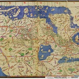
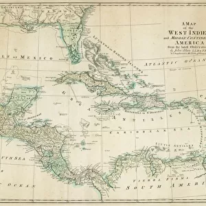
Nieuwe pascaert, van de suyt syde van Yrlandt beginnende van Blasques tot ande Hoeck van Waterfoort. A chart bound in van Keulen's Great and Newly Enlarged Sea Atlas or Waterworld, 1682 (print)
")
![]()
Wall Art and Photo Gifts from Fine Art Finder
Nieuwe pascaert, van de suyt syde van Yrlandt beginnende van Blasques tot ande Hoeck van Waterfoort. A chart bound in van Keulen's Great and Newly Enlarged Sea Atlas or Waterworld, 1682 (print)
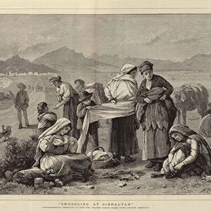
7340067 Nieuwe pascaert, van de suyt syde van Yrlandt beginnende van Blasques tot ande Hoeck van Waterfoort. A chart bound in van Keulen's Great and Newly Enlarged Sea Atlas or Waterworld, 1682 (print) by Keulen, Johannes van (1654-1715); 53x62 cm; National Maritime Museum, London, UK; (add.info.: Creator: Johannes Van Keulen
Bound sheet. Hand col engr. Scale: [ca. 1:575 000 (bar)]. Cartographic Note: Borders graduated for latitude. Bar scales in Dutch miles, Spanish miles and English and French miles [actually leagues]. Additional Places: Ireland, Blaskets, Waterford. Contents Note: Title decorated with a scene of bread and dairy produce.); © National Maritime Museum, Greenwich, London
Media ID 38372204
© © National Maritime Museum, Greenwich, London / Bridgeman Images
Baker Bakerman Bakers Bread Ireland Irish Loaves Patissier Inhabitant
FEATURES IN THESE COLLECTIONS
> Arts
> Artists
> K
> Johannes van Keulen
> Europe
> Republic of Ireland
> Maps
> Europe
> Republic of Ireland
> Waterford
> Europe
> Spain
> Related Images
> Europe
> United Kingdom
> England
> London
> Boroughs
> Greenwich
> Europe
> United Kingdom
> England
> London
> Museums
> Greenwich Heritage Centre
> Europe
> United Kingdom
> England
> London
> Museums
> National Maritime Museum
> Fine Art Finder
> Artists
> Admiral Edward Augustus Inglefield
> Fine Art Finder
> Artists
> Johannes van Keulen
EDITORS COMMENTS
This stunning print of the Nieuwe pascaert, van de suyt syde van Yrlandt captures the intricate beauty and historical significance of cartography in the 17th century. Bound in Johannes van Keulen's 'Great and Newly Enlarged Sea Atlas' or Waterworld from 1682, this chart showcases the southern coast of Ireland from Blasques to Waterford.
The hand-colored engraving is a true work of art, with borders graduated for latitude and bar scales in Dutch miles, Spanish miles, English miles, and French leagues. The title is adorned with a charming scene depicting bread and dairy produce, adding a touch of whimsy to this detailed map.
As you study this print closely, you can almost feel yourself transported back in time to an era when exploration and discovery were at the forefront of human endeavor. The meticulous attention to detail in mapping out not just geographical features but also cultural elements like food production speaks volumes about the craftsmanship involved in creating such works.
Whether you're a history buff, a lover of vintage maps, or simply appreciate fine artistry, this print is sure to captivate your imagination and spark curiosity about the world as it was centuries ago. Display it proudly in your home or office as a testament to the enduring legacy of early cartographers like Johannes van Keulen.
MADE IN THE USA
Safe Shipping with 30 Day Money Back Guarantee
FREE PERSONALISATION*
We are proud to offer a range of customisation features including Personalised Captions, Color Filters and Picture Zoom Tools
SECURE PAYMENTS
We happily accept a wide range of payment options so you can pay for the things you need in the way that is most convenient for you
* Options may vary by product and licensing agreement. Zoomed Pictures can be adjusted in the Cart.