Home > Europe > France > Canton > Landes
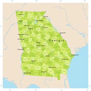
1827 Finley Map Of Georgia Anthony Finley Mapmaker Of The United States In The 19th Century

![]()
Wall Art and Photo Gifts from Universal Images Group (UIG)
1827 Finley Map Of Georgia Anthony Finley Mapmaker Of The United States In The 19th Century
1827, Finley Map of Georgia, Anthony Finley mapmaker of the United States in the 19th century
Universal Images Group (UIG) manages distribution for many leading specialist agencies worldwide
Media ID 38550806
© Artokoloro Quint Lox Limited
1827 Antique Map Latitude Longitude Mappa Mundi Old Antique Plan Old Antique View Ols Antique Map Rare Old Maps Topo
FEATURES IN THESE COLLECTIONS
> Asia
> Georgia
> Related Images
> Europe
> France
> Canton
> Landes
> Historic
> Space exploration
> Maps and Charts
> Early Maps
> Maps and Charts
> Related Images
> Maps and Charts
> World
> Universal Images Group (UIG)
> History
> Historical Maps
EDITORS COMMENTS
Step back in time to 1827 with this stunning print of Anthony Finley's map of Georgia, a masterpiece of cartography from the 19th century. As one of the most renowned mapmakers of his era, Finley's work is a testament to the art and science of geography. This beautifully rendered illustration showcases the state's topography, featuring intricate details such as rivers, mountains, and cities.
The map is a treasure trove for historians and geography enthusiasts alike, offering a glimpse into the region's early development and growth. From its earliest settlements to its bustling cities, this map provides an unparalleled view of Georgia during a pivotal moment in American history.
Finley's attention to detail is evident throughout the print, with precise renderings of latitude and longitude lines that give way to lush illustrations of forests and waterways. The vintage aesthetic adds an air of nostalgia to this piece, making it perfect for framing or displaying as part of your home decor.
Whether you're fascinated by history, geography or simply appreciate beautiful artwork on paper, this antique map print is sure to captivate. So why not take a step back in time and explore the wonders that lie within?
MADE IN THE USA
Safe Shipping with 30 Day Money Back Guarantee
FREE PERSONALISATION*
We are proud to offer a range of customisation features including Personalised Captions, Color Filters and Picture Zoom Tools
SECURE PAYMENTS
We happily accept a wide range of payment options so you can pay for the things you need in the way that is most convenient for you
* Options may vary by product and licensing agreement. Zoomed Pictures can be adjusted in the Cart.