Home > Animals > Mammals > Cats (Wild) > Populator
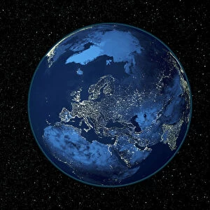
South America at night, satellite image

![]()
Wall Art and Photo Gifts from Science Photo Library
South America at night, satellite image
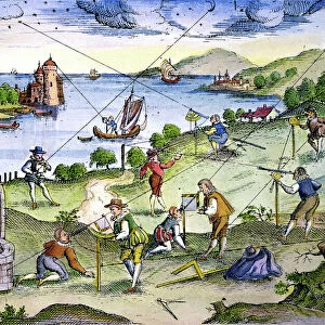
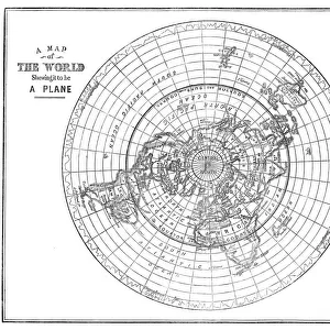
South America at night, satellite image. City lights (yellow) show areas of dense population, particularly in North America (top left) and South Americas coasts. The centre of South America is mostly uninhabited, as is Antarctica (bottom right). This image was produced by combining data from the Defense Meteorological Satellite Program (DMSP) and NOas POES satellites
Science Photo Library features Science and Medical images including photos and illustrations
Media ID 1705079
© PLANETARY VISIONS LTD/SCIENCE PHOTO LIBRARY
Antarctic Antarctica Artificial Lighting Caribbean Central America Cities City Combined Data Continent Continents Dark Darkness Defense Meteorological Demographics Demography Densely Populated Density Distribution Dmsp Earth Observation Earth Science Energy Environmental Impact From Space Globe Human Geography Human Population Inhabited Light Light Pollution Lights Night Night Time Noaa Pacific Ocean Poes Polar Orbiter Populated Population Power Region Satellite Satellite Image Satellite Program South America South Pole Sparsely Populated Uninhabited Urban Urban Geography Urbanisation Urbanised Urbanization Urbanized World The Americas
FEATURES IN THESE COLLECTIONS
> Animals
> Mammals
> Cats (Wild)
> Populator
> Arts
> Artists
> O
> Oceanic Oceanic
> Europe
> Related Images
> North America
> Related Images
> Science Photo Library
> Aerial and Satellite
> Science
> Space Exploration
> Planets
> Earth
> South America
> Related Images
EDITORS COMMENTS
This print showcases the stunning view of South America at night, as captured by satellite imagery. The city lights, depicted in a warm yellow hue, reveal areas of high population density across the continent. Notably, North America and the coastlines of South America shine brightly with urbanization and technological advancements. However, what truly stands out is the vast expanse of darkness that engulfs the center of South America and Antarctica. These regions remain mostly uninhabited, emphasizing their untouched beauty and remoteness. In fact, Antarctica appears as a dark silhouette in contrast to the illuminated world around it. The image was meticulously created by combining data from two satellites: Defense Meteorological Satellite Program (DMSP) and NOAA's Polar-orbiting Operational Environmental Satellites (POES). This amalgamation allowed for an accurate representation of Earth's surface at night. As we marvel at this breathtaking sight from space, it prompts us to contemplate various aspects such as geography, demography, environmental impact, and light pollution caused by artificial lighting. It serves as a reminder of humanity's distribution across continents and our ability to shape landscapes through urbanization. Science Photo Library has once again provided us with an awe-inspiring glimpse into our planet's intricate tapestry seen from above – a testament to both human ingenuity and Earth’s natural wonders.
MADE IN THE USA
Safe Shipping with 30 Day Money Back Guarantee
FREE PERSONALISATION*
We are proud to offer a range of customisation features including Personalised Captions, Color Filters and Picture Zoom Tools
SECURE PAYMENTS
We happily accept a wide range of payment options so you can pay for the things you need in the way that is most convenient for you
* Options may vary by product and licensing agreement. Zoomed Pictures can be adjusted in the Cart.