
Portolan Collection
Portolan charts, also known as portolans, were navigational maps used by sailors during the Age of Exploration


All Professionally Made to Order for Quick Shipping
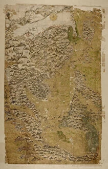
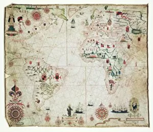
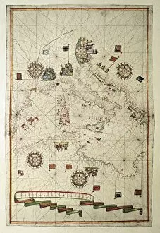
Portolan charts, also known as portolans, were navigational maps used by sailors during the Age of Exploration. These intricate and detailed maps provided vital information about coastlines, ports, and landmarks to aid in safe navigation. One notable example is The Selden Map of China, created by a Chinese master artist. This map showcases the vastness of China's territory and its coastal regions in stunning detail. Another remarkable portolan chart from 1591 depicts the Pacific Ocean. Sailors relied on this map to navigate through uncharted waters and discover new lands across the vast expanse of the ocean. The 17th-century nautical map of the Atlantic offers insights into European exploration during that era. It highlights major trade routes between continents and provides valuable information for seafarers venturing into unknown territories. An Atlas of the World in 33 Maps produced in Venice on September 1st, 1553 captures Italy's beauty with ink on vellum. This exquisite piece showcases Italy's diverse landscapes and serves as a testament to cartographic artistry. A central part of Europe is depicted in a portolan chart from 1582. This map reveals key cities and their surrounding areas, aiding sailors in navigating through Europe's waterways. Nautical atlases like one from 1651 showcase important trading hubs such as Marseille and Genoa along with their respective ports. These maps played an essential role in facilitating maritime commerce during that period. The Cantino planisphere from 1502 remains an anonymous masterpiece displaying accurate representations of England, Scotland, Ireland, and other European countries at that time. Crete takes center stage on another nautical atlas from 1651 made using ink on vellum. Its detailed depiction allows mariners to safely navigate around this island while exploring nearby waters. A French Coast map dating back to1520 provides crucial details about England, Scotland, Ireland - all inked onto vellum.