Home > Europe > Italy > Emilia-Romagna > Ravenna
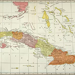
Geography Atlas: representation of the Caribbean Sea region, the Greater Antilles (Cuba, Jamaica, Hispaniola) and the Lesser Antilles. Map from an Atlas of 1857. Biblioteca Jose Marti, Havana, Cuba
 and the Lesser Antilles. Map from an Atlas of 1857. Biblioteca Jose Marti, Havana, Cuba")
![]()
Wall Art and Photo Gifts from Fine Art Finder
Geography Atlas: representation of the Caribbean Sea region, the Greater Antilles (Cuba, Jamaica, Hispaniola) and the Lesser Antilles. Map from an Atlas of 1857. Biblioteca Jose Marti, Havana, Cuba
VEN5030072 Geography Atlas: representation of the Caribbean Sea region, the Greater Antilles (Cuba, Jamaica, Hispaniola) and the Lesser Antilles. Map from an Atlas of 1857. Biblioteca Jose Marti, Havana, Cuba.; (add.info.: Geography Atlas: representation of the Caribbean Sea region, the Greater Antilles (Cuba, Jamaica, Hispaniola) and the Lesser Antilles. Map from an Atlas of 1857. Biblioteca Jose Marti, Havana, Cuba.); Photo © Marco Ravenna
Media ID 38275002
© © Marco Ravenna / Bridgeman Images
Amerique Centrale Amerique Du Nord Caraïbes Caribbean Caribbean Island Carte Geographique Central America Cuba Cuba Cubain Cubaine Cubains Cubaines Cuban Etats Unis Geographie Jamaica Jamaican Stockravenna Geographical Map
FEATURES IN THESE COLLECTIONS
> Europe
> Italy
> Emilia-Romagna
> Ravenna
> Fine Art Finder
> Artists
> Marcantonio Bassetti
> Maps and Charts
> Early Maps
> Maps and Charts
> Related Images
> North America
> Cuba
> Cuba Heritage Sites
> Old Havana and its Fortification System
> North America
> Cuba
> Havana
> North America
> Cuba
> Maps
> North America
> Cuba
> Related Images
> North America
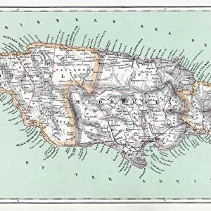
> Jamaica
> Maps
> North America
> Jamaica
> Related Images
EDITORS COMMENTS
This stunning print captures a detailed representation of the Caribbean Sea region, showcasing the Greater Antilles including Cuba, Jamaica, and Hispaniola, as well as the Lesser Antilles. Dating back to 1857, this map from an Atlas provides a historical glimpse into the geography of these islands during the 19th century.
Located in the Biblioteca Jose Marti in Havana, Cuba, this rare piece offers a unique perspective on the layout of these iconic Caribbean destinations. The intricate engraving highlights not only the physical features of each island but also their strategic positioning within the region.
As we admire this vintage map, we are transported back in time to an era when exploration and discovery shaped our understanding of the world. The attention to detail and precision in cartography is evident in every line and contour depicted on this piece.
From bustling cities to pristine coastlines, each island's distinct characteristics are beautifully illustrated on this map. It serves as a reminder of the rich history and cultural diversity that define these vibrant Caribbean nations.
Whether you have a personal connection to these islands or simply appreciate their beauty from afar, this Geography Atlas print is sure to captivate your imagination and inspire wanderlust for these tropical paradises.
MADE IN THE USA
Safe Shipping with 30 Day Money Back Guarantee
FREE PERSONALISATION*
We are proud to offer a range of customisation features including Personalised Captions, Color Filters and Picture Zoom Tools
SECURE PAYMENTS
We happily accept a wide range of payment options so you can pay for the things you need in the way that is most convenient for you
* Options may vary by product and licensing agreement. Zoomed Pictures can be adjusted in the Cart.