Home > Science > Space Exploration > Planets > Earth
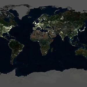
Europe At Night With Cloud Coverage, True Colour Satellite Image. True colour satellite image of Europe at night with cloud coverage. This image in Lambert Conformal Conic projection was compiled from data acquired by LANDSAT 5 & 7 satellites

![]()
Wall Art and Photo Gifts from Design Pics
Europe At Night With Cloud Coverage, True Colour Satellite Image. True colour satellite image of Europe at night with cloud coverage. This image in Lambert Conformal Conic projection was compiled from data acquired by LANDSAT 5 & 7 satellites
Design Pics offers Distinctively Different Imagery representing over 1,500 contributors
Media ID 24589232
© UIG / Design Pics
Aerial Alps Atlantic Ocean Baltic Sea Carpathians Continent Earth Earth Science Environment Geographic Illustration Greenland Iceland Mediterranean Sea Night North Sea Planet Planet Earth Pyrenees Relief Satellite Satellite Image Sciences Space Uig Premium 1 Uig1 Satellite And Aerial Black Sea Nort
FEATURES IN THESE COLLECTIONS
> Aerial Photography
> Iceland
> Aerial Photography
> Related Images
> Design Pics
> Design Pics Art
> Design Pics
> Universal Images Group
> Design Pics
> Update - March 23, 2022
> Europe
> Iceland
> Related Images
> North America
> Greenland
> Maps
> North America
> Greenland
> Related Images
> Science
> Space Exploration
> Planets
> Earth
EDITORS COMMENTS
This print showcases Europe at night, revealing the continent's intricate web of city lights and cloud coverage. The true color satellite image was meticulously compiled using data acquired by LANDSAT 5 & 7 satellites, resulting in a stunning visual representation of our planet's second smallest continent. The Lambert Conformal Conic projection used to create this image ensures accurate depiction of Europe's geography. From the majestic Pyrenees and Alps mountain ranges to the vast expanse of Greenland, every detail is brought to life in this illustration. The inclusion of Iceland adds an element of intrigue as its volcanic landscapes contrast with the surrounding seas. As we gaze upon this image, we are reminded not only of Europe's beauty but also its interconnectedness. The Atlantic Ocean stretches out towards North Sea, Mediterranean Sea, Baltic Sea, and Black Sea - all vital waterways that have shaped European history and culture. This print serves as a testament to the advancements in space sciences and earth science research. It allows us to appreciate both the natural wonders and human-made structures that define our world from above. Whether displayed in a home or office setting, this striking image offers a unique perspective on Europe's diverse landscapes while igniting curiosity about our planet Earth as a whole.
MADE IN THE USA
Safe Shipping with 30 Day Money Back Guarantee
FREE PERSONALISATION*
We are proud to offer a range of customisation features including Personalised Captions, Color Filters and Picture Zoom Tools
SECURE PAYMENTS
We happily accept a wide range of payment options so you can pay for the things you need in the way that is most convenient for you
* Options may vary by product and licensing agreement. Zoomed Pictures can be adjusted in the Cart.