Home > Europe > France > Canton > Landes
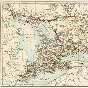
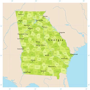
1862 Johnson Map Of Georgia And Alabama Topography

![]()
Wall Art and Photo Gifts from Universal Images Group (UIG)
1862 Johnson Map Of Georgia And Alabama Topography
1862, Johnson Map of Georgia and Alabama
Universal Images Group (UIG) manages distribution for many leading specialist agencies worldwide
Media ID 38551526
© Artokoloro Quint Lox Limited
1862 Antique Map Latitude Longitude Mappa Mundi Old Antique Plan Old Antique View Ols Antique Map Rare Old Maps Topo
FEATURES IN THESE COLLECTIONS
> Asia
> Georgia
> Related Images
> Europe
> France
> Canton
> Landes
> Historic
> Space exploration
> Maps and Charts
> Early Maps
> Maps and Charts
> Related Images
> Maps and Charts
> World
> Universal Images Group (UIG)
> History
> Historical Maps
EDITORS COMMENTS
Step back in time to the mid-19th century with this stunning print of the 1862 Johnson Map of Georgia and Alabama Topography. This vintage map is a treasure trove of geographical information, showcasing the region's terrain, cities, rivers, and roads in exquisite detail.
The map was created by A.J. Johnson, a renowned cartographer of his time, who skillfully blended artistic flair with scientific accuracy to produce a work that is both beautiful and informative. The intricate illustrations depict the rolling hills, mountains, and valleys of Georgia and Alabama, as well as major cities like Atlanta and Montgomery.
This historic map offers a fascinating glimpse into the geography of these two states during the American Civil War era. It provides valuable insights into the strategic importance of each location, from military strongholds to key transportation routes.
Printed on high-quality paper for durability and longevity, this reproduction is perfect for framing or displaying proudly on your wall. Whether you're an history buff or simply appreciate vintage maps as works of art, this 1862 Johnson Map of Georgia and Alabama Topography is sure to captivate your imagination.
MADE IN THE USA
Safe Shipping with 30 Day Money Back Guarantee
FREE PERSONALISATION*
We are proud to offer a range of customisation features including Personalised Captions, Color Filters and Picture Zoom Tools
SECURE PAYMENTS
We happily accept a wide range of payment options so you can pay for the things you need in the way that is most convenient for you
* Options may vary by product and licensing agreement. Zoomed Pictures can be adjusted in the Cart.