Home > Europe > France > Canton > Landes
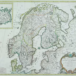
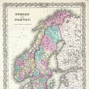
1855 Colton Map Of Scandinavia Norway Sweden

![]()
Wall Art and Photo Gifts from Universal Images Group (UIG)
1855 Colton Map Of Scandinavia Norway Sweden
1855, Colton Map of Scandinavia, Norway, Sweden, Finland
Universal Images Group (UIG) manages distribution for many leading specialist agencies worldwide
Media ID 38549088
© Artokoloro Quint Lox Limited
1855 Finland Norway Sweden Antique Map Latitude Longitude Mappa Mundi Old Antique Plan Old Antique View Ols Antique Map Rare Old Maps Topo
FEATURES IN THESE COLLECTIONS
> Europe
> Finland
> Related Images
> Europe
> France
> Canton
> Landes
> Europe
> Norway
> Related Images
> Europe
> Sweden
> Related Images
> Historic
> Space exploration
> Maps and Charts
> Early Maps
> Universal Images Group (UIG)
> History
> Historical Maps
EDITORS COMMENTS
Step back in time to the mid-19th century with this stunning 1855 Colton Map of Scandinavia, Norway, and Sweden. This beautifully detailed print showcases the geographical landscape of these Nordic countries during a pivotal moment in their history. The map is filled with intricate illustrations of mountains, rivers, and cities, providing a fascinating glimpse into the region's topography.
The map is titled "Scandinavia or Denmark Proper" and features Norway, Sweden, Finland, and parts of Russia. It highlights major cities such as Oslo, Stockholm, and Helsinki, as well as notable landmarks like the Norwegian fjords and Swedish lakes. The cartographer's attention to detail is evident in the inclusion of latitude and longitude lines, making it easy to navigate this vast region.
This vintage map is not only a beautiful piece of art but also a valuable historical artifact that provides insight into how our understanding of geography has evolved over time. It's a must-have for anyone interested in cartography, geography, or Scandinavian history. Hang it on your wall as a unique conversation starter or give it as a thoughtful gift to any history buff.
MADE IN THE USA
Safe Shipping with 30 Day Money Back Guarantee
FREE PERSONALISATION*
We are proud to offer a range of customisation features including Personalised Captions, Color Filters and Picture Zoom Tools
SECURE PAYMENTS
We happily accept a wide range of payment options so you can pay for the things you need in the way that is most convenient for you
* Options may vary by product and licensing agreement. Zoomed Pictures can be adjusted in the Cart.