Home > Europe > France > Canton > Landes
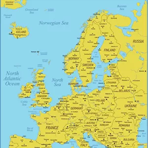
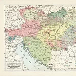
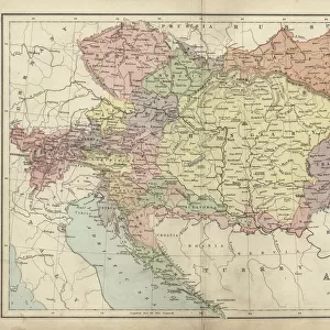
1855 Colton Map Of Austria Hungary And The Czech Republic

![]()
Wall Art and Photo Gifts from Universal Images Group (UIG)
1855 Colton Map Of Austria Hungary And The Czech Republic
1855, Colton Map of Austria, Hungary and the Czech Republic
Universal Images Group (UIG) manages distribution for many leading specialist agencies worldwide
Media ID 38549032
© Artokoloro Quint Lox Limited
1855 Antique Map Latitude Longitude Mappa Mundi Old Antique Plan Old Antique View Ols Antique Map Rare Old Maps Topo
FEATURES IN THESE COLLECTIONS
> Europe
> Austria
> Related Images
> Europe
> Czech Republic
> Maps
> Europe
> Czech Republic
> Related Images
> Europe
> France
> Canton
> Landes
> Europe
> Hungary
> Related Images
> Historic
> Space exploration
> Maps and Charts
> Early Maps
> Universal Images Group (UIG)
> History
> Historical Maps
EDITORS COMMENTS
Step back in time to the mid-19th century with this stunning 1855 Colton Map of Austria, Hungary, and the Czech Republic. This vintage print is a remarkable piece of cartography that showcases the geographical boundaries and topographical features of these regions during a pivotal moment in history.
The map is a testament to the meticulous attention to detail and craftsmanship of its creator, as it accurately depicts mountains, rivers, cities, and towns with precision. The intricate illustrations are not only aesthetically pleasing but also provide valuable information for travelers and explorers seeking to navigate this vast territory.
This historic map is more than just a decorative piece; it's a window into the past that offers insight into the cultural, economic, and political landscape of Europe during this era. It's an opportunity to appreciate the evolution of cartography over time and marvel at the advancements made in mapping technology.
Whether you're an historian, geography enthusiast, or simply someone who appreciates vintage artistry, this 1855 Colton Map of Austria, Hungary, and the Czech Republic is sure to captivate your imagination. Its aged beauty makes it an excellent addition to any collection or room decor.
MADE IN THE USA
Safe Shipping with 30 Day Money Back Guarantee
FREE PERSONALISATION*
We are proud to offer a range of customisation features including Personalised Captions, Color Filters and Picture Zoom Tools
SECURE PAYMENTS
We happily accept a wide range of payment options so you can pay for the things you need in the way that is most convenient for you
* Options may vary by product and licensing agreement. Zoomed Pictures can be adjusted in the Cart.