Home > Europe > France > Canton > Landes
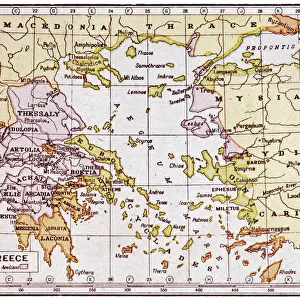
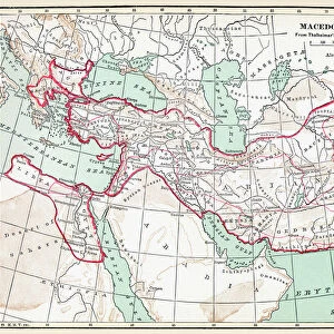
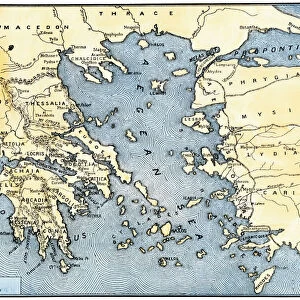
1853 Mitchell Map Of Turkey In Europe And Greece

![]()
Wall Art and Photo Gifts from Universal Images Group (UIG)
1853 Mitchell Map Of Turkey In Europe And Greece
1853, Mitchell Map of Turkey in Europe and Greece, Greece, Balkans, Macedonia
Universal Images Group (UIG) manages distribution for many leading specialist agencies worldwide
Media ID 38548982
© Artokoloro Quint Lox Limited
1853 Balkans Greece Macedonia Antique Map Latitude Longitude Mappa Mundi Old Antique Plan Old Antique View Ols Antique Map Rare Old Maps Topo
FEATURES IN THESE COLLECTIONS
> Asia
> Turkey
> Related Images
> Europe
> France
> Canton
> Landes
> Europe
> Greece
> Related Images
> Europe
> Macedonia
> Related Images
> Historic
> Ancient civilizations
> Ancient Greece
> Greek history
> Historic
> Space exploration
> Maps and Charts
> Early Maps
> Universal Images Group (UIG)
> History
> Historical Maps
EDITORS COMMENTS
Step back in time to the mid-19th century with this stunning print of Mitchell's 1853 Map of Turkey in Europe and Greece. This beautifully illustrated map showcases the geographic boundaries, topography, and cultural regions of the Balkans during a pivotal moment in history.
The intricate details on this vintage map reveal the complex network of territories, cities, and trade routes that crisscrossed the region. From the Ottoman Empire's vast dominion over much of Southeastern Europe to the fledgling Greek state struggling for independence, every aspect of this historic era is meticulously rendered.
Not only a testament to cartographic skill but also a window into a bygone era, this map invites us to explore the ancient landscapes that shaped modern-day nations. The faded colors and worn edges evoke a sense of nostalgia for times past, while the sheer scale and detail transport us back to an age when exploration was still a thrilling adventure.
Whether you're an armchair traveler or simply fascinated by historical geography, this print is sure to delight. Hang it proudly as a conversation piece or gift it to someone who shares your passion for discovery.
MADE IN THE USA
Safe Shipping with 30 Day Money Back Guarantee
FREE PERSONALISATION*
We are proud to offer a range of customisation features including Personalised Captions, Color Filters and Picture Zoom Tools
SECURE PAYMENTS
We happily accept a wide range of payment options so you can pay for the things you need in the way that is most convenient for you
* Options may vary by product and licensing agreement. Zoomed Pictures can be adjusted in the Cart.