Home > Europe > France > Canton > Landes
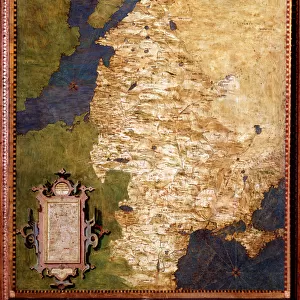
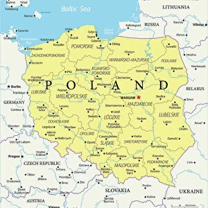
1799 Cary Map Of Poland Prussia And Lithuania

![]()
Wall Art and Photo Gifts from Universal Images Group (UIG)
1799 Cary Map Of Poland Prussia And Lithuania
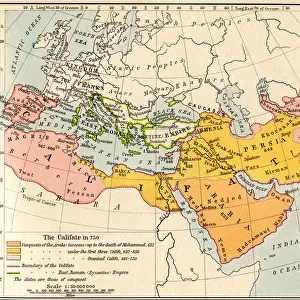
1799, Cary Map of Poland, Prussia and Lithuania, John Cary, 1754 - 1835, was an English cartographer, John Cary, 1754 - 1835, English cartographer
Universal Images Group (UIG) manages distribution for many leading specialist agencies worldwide
Media ID 38548297
© Artokoloro Quint Lox Limited
1754 – 1835 1799 English Cartographer John Cary Was An English Cartographer Antique Map Latitude Longitude Mappa Mundi Old Antique Plan Old Antique View Ols Antique Map Rare Old Maps Topo
FEATURES IN THESE COLLECTIONS
> Europe
> France
> Canton
> Landes
> Europe
> Lithuania
> Related Images
> Europe
> Poland
> Related Images
> Historic
> Space exploration
> Maps and Charts
> Early Maps
> Maps and Charts
> Related Images
> Universal Images Group (UIG)
> History
> Historical Maps
EDITORS COMMENTS
Step back in time to the late 18th century with this exquisite print of John Cary's 1799 map of Poland, Prussia, and Lithuania. This stunning illustration is a testament to the cartographer's skill and attention to detail, showcasing the intricate borders, rivers, and cities of these Eastern European regions.
Published in 1799 by renowned English cartographer John Cary (1754-1835), this map is a rare example of his work during a period when Europe was undergoing significant political changes. The map provides a fascinating glimpse into the geography and topography of the region at that time, featuring detailed illustrations of mountains, forests, and waterways.
This vintage print is not only a beautiful piece of art but also an important historical artifact that offers insight into the evolution of cartography and our understanding of the world. It would make a unique addition to any collection or serve as a striking decorative piece for any room.
The richly detailed design features intricate typography and ornate borderwork, making it both aesthetically pleasing and historically significant. Whether you're an enthusiast of history, geography, or simply appreciate beautiful prints, this antique map is sure to captivate.
MADE IN THE USA
Safe Shipping with 30 Day Money Back Guarantee
FREE PERSONALISATION*
We are proud to offer a range of customisation features including Personalised Captions, Color Filters and Picture Zoom Tools
SECURE PAYMENTS
We happily accept a wide range of payment options so you can pay for the things you need in the way that is most convenient for you
* Options may vary by product and licensing agreement. Zoomed Pictures can be adjusted in the Cart.