Home > Europe > France > Canton > Landes
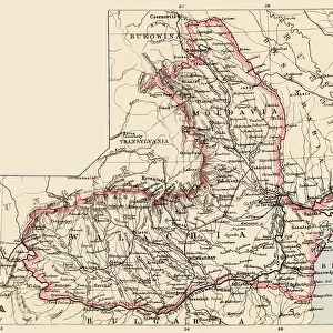
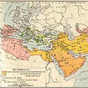
1710 De La Feuille Map Of Transylvania And Moldova

![]()
Wall Art and Photo Gifts from Universal Images Group (UIG)
1710 De La Feuille Map Of Transylvania And Moldova
1710, De La Feuille Map of Transylvania and Moldova
Universal Images Group (UIG) manages distribution for many leading specialist agencies worldwide
Media ID 38547829
© Artokoloro Quint Lox Limited
1710 Antique Map Latitude Longitude Mappa Mundi Old Antique Plan Old Antique View Ols Antique Map Rare Old Maps Topo
FEATURES IN THESE COLLECTIONS
> Europe
> France
> Canton
> Landes
> Europe
> Moldova
> Related Images
> Historic
> Space exploration
> Maps and Charts
> Early Maps
> Maps and Charts
> Related Images
> Maps and Charts
> World
> Universal Images Group (UIG)
> History
> Historical Maps
EDITORS COMMENTS
Step into the 18th century with this stunning print of the 1710 De La Feuille Map of Transylvania and Moldova. This exquisite illustration is a testament to the art of cartography, showcasing the geographical boundaries and topographical features of these regions with remarkable detail.
The map's intricate design is a masterclass in geometric precision, with carefully drawn lines and symbols indicating mountains, rivers, forests, and cities. The use of color adds an extra layer of depth and visual interest, with shades of blue and green used to distinguish between different territories.
This historic map offers a fascinating glimpse into the past, providing insight into the way people understood their world during this period. It's a reminder that even centuries ago, humans were driven by a desire to explore and understand their surroundings.
Whether you're an history buff or simply someone who appreciates beautiful illustrations, this print is sure to captivate. Hang it on your wall as a unique piece of decorative art or use it as inspiration for your next adventure - either way, you'll be transported back in time to an era when exploration was at its peak.
MADE IN THE USA
Safe Shipping with 30 Day Money Back Guarantee
FREE PERSONALISATION*
We are proud to offer a range of customisation features including Personalised Captions, Color Filters and Picture Zoom Tools
SECURE PAYMENTS
We happily accept a wide range of payment options so you can pay for the things you need in the way that is most convenient for you
* Options may vary by product and licensing agreement. Zoomed Pictures can be adjusted in the Cart.