Home > Arts > Artists > O > Oceanic Oceanic
EXPL2A-00284

![]()
Wall Art and Photo Gifts from North Wind
EXPL2A-00284
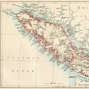
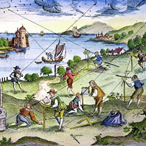
Early map of Hudsons Strait and Hudsons Bay, 1662, in Arctic Canada.
Hand-colored 19th-century woodcut reproduction
North Wind Picture Archives brings history to life with stock images and hand-colored illustrations
Media ID 5879426
© North Wind Picture Archives
1600s 17th Century Arctic Canada Canadian Cartography Colonial Colony Compass Discover Exploration Explore French French Canada Henry Hudson Hudson Maritime Navigation New France Northwest Passage Ocean Quebec Strait 1662 Arctic Circle Baffin Island Davis Strait Hudson Bay Hudson Strait Hudsons
FEATURES IN THESE COLLECTIONS
> Arts
> Artists
> O
> Oceanic Oceanic
> Historic
> Colonial America illustrations
> Colonial America
> Historic
> Colonial America illustrations
> Historic
> Colonial history
> Colonial art and artists
> Maps and Charts
> Early Maps
> North America
> Canada
> Maps
> North Wind Picture Archives
> Canadian history
> North Wind Picture Archives
> Maps
EDITORS COMMENTS
This vintage print takes us back to the 17th century, offering a glimpse into the early exploration and colonial history of Arctic Canada. The hand-colored woodcut reproduction showcases an intricate map titled "Early Map of Hudsons Strait and Hudsons Bay, 1662". The map itself is a testament to the artistry and precision of cartography during that era. It depicts the vast expanse of Hudson's Bay, with its intricate network of straits and islands. Baffin Island stands prominently in the north, while Quebec lies further south along the St. Lawrence River. As we delve into this historical artifact, we are reminded of intrepid explorers like Henry Hudson who ventured into these uncharted waters in search of new trade routes to Asia. This map was crucial for their navigation through treacherous passages such as Davis Strait and Hudson Strait. The French influence on Canadian history becomes evident as we observe references to New France and French Canada within this artwork. The quest for discovering a Northwest Passage also looms large in this depiction. With its rich colors and meticulous details, this print serves as a visual time machine transporting us back to an age when maritime exploration shaped North America's destiny. It invites us to appreciate both the artistic beauty inherent in cartography as well as the bravery exhibited by those who dared venture into unknown territories centuries ago.
MADE IN THE USA
Safe Shipping with 30 Day Money Back Guarantee
FREE PERSONALISATION*
We are proud to offer a range of customisation features including Personalised Captions, Color Filters and Picture Zoom Tools
SECURE PAYMENTS
We happily accept a wide range of payment options so you can pay for the things you need in the way that is most convenient for you
* Options may vary by product and licensing agreement. Zoomed Pictures can be adjusted in the Cart.