Home > North America > United States of America > New York > New York > Maps
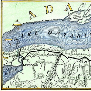
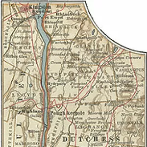
Map of New York State, c.1900 (engraving)
")
![]()
Wall Art and Photo Gifts from Fine Art Finder
Map of New York State, c.1900 (engraving)
533109 Map of New York State, c.1900 (engraving); (add.info.: Map of western New York State, with inset map of Buffalo, Niagara Frontier, and Rochester, circa 1902, from the 10th edition of Encyclopaedia Britannica.); Encyclopaedia Britannica/UIG
Media ID 38454192
© Encyclopaedia Britannica/UIG / Bridgeman Images
1902 19th Century Style Boundary Buffalo Geographical Border Guidance Illustration Technique Navigational Equipment New York State Old Fashioned Part Of Physical Geography Rochester State The Past Us State Border Western Script Lake Ontario
FEATURES IN THESE COLLECTIONS
> Fine Art Finder
> Temp Classification
> Maps and Charts
> Related Images
> North America
> United States of America
> Lakes
> Lake Ontario
> North America
> United States of America
> Lakes
> Related Images
> North America
> United States of America
> Maps
> North America
> United States of America
> New York
> Buffalo
> North America
> United States of America
> New York
> New York
> Maps
> North America
> United States of America
> New York
> New York
> Related Images
> North America
> United States of America
> New York
> Related Images
> North America
> United States of America
> New York
> Rochester
EDITORS COMMENTS
This stunning engraving of a Map of New York State from around 1900 offers a glimpse into the past, showcasing the intricate details and craftsmanship of 19th-century cartography. The map features the western region of New York State, with an inset highlighting Buffalo, Niagara Frontier, and Rochester.
The old-fashioned style and Western script used in this map evoke a sense of nostalgia for a bygone era when exploration and navigation relied on physical maps rather than digital technology. The coastline, boundaries, and geographical borders are meticulously depicted, providing valuable guidance for travelers and explorers at the time.
As we gaze upon this historical artifact, we can imagine the adventures that took place in these lands over a century ago. From Lake Ontario to state borders, every detail on this map tells a story of discovery and settlement in early 20th-century America.
Whether you have personal ties to New York State or simply appreciate the artistry of vintage maps, this print is sure to captivate your imagination. Let it transport you back in time to an age when maps were not just tools for navigation but works of art that captured the essence of a place.
MADE IN THE USA
Safe Shipping with 30 Day Money Back Guarantee
FREE PERSONALISATION*
We are proud to offer a range of customisation features including Personalised Captions, Color Filters and Picture Zoom Tools
SECURE PAYMENTS
We happily accept a wide range of payment options so you can pay for the things you need in the way that is most convenient for you
* Options may vary by product and licensing agreement. Zoomed Pictures can be adjusted in the Cart.