Home > Africa > Cape Verde > Maps
Map of the World showing the chief voyages of exploration, to 1522. (print)
")
![]()
Wall Art and Photo Gifts from Fine Art Finder
Map of the World showing the chief voyages of exploration, to 1522. (print)
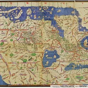
7420054 Map of the World showing the chief voyages of exploration, to 1522. (print); (add.info.: Map of the World showing the chief voyages of exploration, to 1522. The black line down the middle of the map denotes The Treaty of Tordesillas, 1494, which divided the newly discovered lands outside Europe between the Portuguese Empire and the Spanish Empire (Crown of Castile), along a meridian 370 leagues west of the Cape Verde islands, off the west coast of Africa. That line of demarcation was about halfway between the Cape Verde islands (already Portuguese) and the islands visited by Christopher Columbus on his first voyage (claimed for Castile and Leon), named in the treaty as Cipangu and Antillia (Cuba and Hispaniola). This Treaty modified an earlier division proposed by Pope Alexander VI which was known as the Pope's Line. From the book Outline of History by H.G. Wells, published 1920.); Photo © Ken Welsh. All rights reserved 2024
Media ID 38519504
© © Ken Welsh. All rights reserved 2024 / Bridgeman Images
Chart Diagram Excursion Explore Graph Map Of The World World Map Geographer
FEATURES IN THESE COLLECTIONS
> Africa
> Cape Verde
> Maps
> Africa
> Cape Verde
> Related Images
> Europe
> Portugal
> Related Images
> Europe
> Spain
> Related Images
> Fine Art Finder
> Artists
> Nicholas Pocock
> Maps and Charts
> Early Maps
EDITORS COMMENTS
This print of a Map of the World showing the chief voyages of exploration, to 1522, is a fascinating glimpse into the early days of global exploration. The intricate details on this map highlight the various expeditions taken by explorers such as Christopher Columbus and Ferdinand Magellan, as they ventured into uncharted territories in search of new lands and riches.
The black line down the middle of the map represents The Treaty of Tordesillas, signed in 1494, which divided newly discovered lands between the Portuguese and Spanish Empires. This historic agreement marked a significant moment in history, shaping future colonial ambitions and territorial disputes.
As you study this map closely, you can trace the routes taken by these brave explorers across vast oceans and unknown continents. Each line drawn on this map tells a story of courage, determination, and discovery that forever changed our understanding of the world.
This print serves as a reminder of humanity's insatiable curiosity and thirst for knowledge, driving us to explore beyond our known boundaries in pursuit of new horizons. It is a testament to the spirit of adventure that continues to inspire generations to push further into uncharted territories both on land and at sea.
MADE IN THE USA
Safe Shipping with 30 Day Money Back Guarantee
FREE PERSONALISATION*
We are proud to offer a range of customisation features including Personalised Captions, Color Filters and Picture Zoom Tools
SECURE PAYMENTS
We happily accept a wide range of payment options so you can pay for the things you need in the way that is most convenient for you
* Options may vary by product and licensing agreement. Zoomed Pictures can be adjusted in the Cart.