Home > Europe > United Kingdom > England > London > Museums > National Maritime Museum
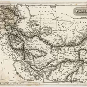
Plans of Ports, Dalrymple, Alexander published in 1791 ID Number 41167-2001 A plane chart of part of the Gulf of Persia, partly corrected by Lieut. Edward Harvey 1778, 1791 (print)
")
![]()
Wall Art and Photo Gifts from Fine Art Finder
Plans of Ports, Dalrymple, Alexander published in 1791 ID Number 41167-2001 A plane chart of part of the Gulf of Persia, partly corrected by Lieut. Edward Harvey 1778, 1791 (print)
7340870 Plans of Ports, Dalrymple, Alexander published in 1791 ID Number 41167-2001 A plane chart of part of the Gulf of Persia, partly corrected by Lieut. Edward Harvey 1778, 1791 (print) by Dalrymple, Alexander (18th-19th century); National Maritime Museum, London, UK; (add.info.: Creator: Dalrymple, Alexander (18th-19th century)); © National Maritime Museum, Greenwich, London
Media ID 38372282
© © National Maritime Museum, Greenwich, London / Bridgeman Images
Boat Dock Coast Line Harbor Area Harbour Area Harbours Iran Iranian Iranians Persia Persians Port Area Geographer Seawater
FEATURES IN THESE COLLECTIONS
> Asia
> Iran
> Related Images
> Europe
> United Kingdom
> England
> London
> Boroughs
> Greenwich
> Europe
> United Kingdom
> England
> London
> Museums
> Greenwich Heritage Centre
> Europe
> United Kingdom
> England
> London
> Museums
> National Maritime Museum
> Europe
> United Kingdom
> England
> London
> Towns
> Greenwich
> Europe
> United Kingdom
> Heritage Sites
> Maritime Greenwich
> Europe
> United Kingdom
> Maps
> Fine Art Finder
> Artists
> Alexander Dalrymple
> Maps and Charts
> Early Maps
> Maps and Charts
> Related Images
EDITORS COMMENTS
This stunning print captures the intricate and detailed Plans of Ports by Alexander Dalrymple, published in 1791. The map, partly corrected by Lieutenant Edward Harvey in 1778, provides a fascinating glimpse into the geography and cartography of the Gulf of Persia during the 18th century.
Dalrymple's expertise as a geographer is evident in this plane chart, showcasing coastlines, shorelines, and maritime features with precision and accuracy. The map not only serves as a navigational tool but also as a historical artifact that sheds light on the Middle Eastern region at that time.
The black-and-white aesthetic adds to the timeless quality of this print, emphasizing the importance of these plans for sailors, explorers, and historians alike. The attention to detail in depicting ports, harbors, and coastal areas reflects Dalrymple's dedication to his craft and his commitment to providing valuable information for seafarers.
As we gaze upon this image from centuries past, we are transported back in time to an era where maps were essential tools for understanding the world around us. This print is not just a piece of art but a window into history that continues to captivate viewers with its beauty and significance.
MADE IN THE USA
Safe Shipping with 30 Day Money Back Guarantee
FREE PERSONALISATION*
We are proud to offer a range of customisation features including Personalised Captions, Color Filters and Picture Zoom Tools
SECURE PAYMENTS
We happily accept a wide range of payment options so you can pay for the things you need in the way that is most convenient for you
* Options may vary by product and licensing agreement. Zoomed Pictures can be adjusted in the Cart.